193 produkter
193 produkter


193 produkter
137 Zoom - Guadeloupe; St-Marin & St. Barthelemy
Ordinær pris 149,00 krDetailed map of Guadeloupe, St-Martin, St-Barthelemy in scale 1:80.000. Inset maps of Pointre-á-Pitre, Basse-Terre, Le Gosier, Saint-Francois & Sainte-Anne.
173 Zoom - USA Great Lakes
Ordinær pris 149,00 krMichelin USA Great Lakes Map 173 (scale: 1:1,267,000) part of Michelin's US regional map series with green covers zooms in close for comprehensive coverage of Wisconsin and Michigan, as well as areas of the other states surrounding the Great Lakes (Minnesota, Iowa, Illinois, Indiana, Ohio, Pennsylvania) and southern Ontario in Canada. It contains city maps for easy driving in Buffalo, Chicago, Cleveland, Detroit, Milwaukee, and Toronto. Michelin star-rated sights and a selection of not-to-be-missed annual events and festivals serve as inspiration for future road trips.
Outdoor enthusiasts have their choice of national parks for scenery and activities: Cuyahoga Valley, Isle Royale and Voyageurs. The map includes a comprehensive index, a distance chart, and a multi-language legend in English and Spanish. Those traveling for business or pleasure, as well as locals traveling further afield, will appreciate Michelin's high standard of clear and accurate mapping and the additional information on parks, events and points of interest to make the journey more enjoyable.
174 Zoom - USA California & Nevada
Ordinær pris 149,00 krMap with comprehensive coverage of California and Nevada, as well as western Utah and Arizona. It contains city maps for easy driving in Las Vegas, Los Angeles, Phoenix, Salt Lake City, San Diego and San Francisco. Michelin star-rated sights and a selection of not-to-be-missed annual events and festivals. Outdoor enthusiasts can choose from multiple national parks for scenery and activities: Bryce Canyon, Channel Islands, Death Valley, Grand Canyon, Great Basin, Joshua Tree, Kings Canyon, Lassen Volcanic, Pinnacles, Redwood, Sequoia, Yosemite and Zion. The QR code on the front cover offers even more travel information on destinations through Michelin's ViaMichelin website.
The map includes a comprehensive index, a distance chart, and a multi-language legend. Those travelling for business or pleasure, will appreciate Michelin's high standard of clear and accurate mapping and the additional information on parks, events and points of interest. Scale 1:1,267.200.
175 Zoom - USA Southern Rockies / Four corners
Ordinær pris 149,00 krFolded map with comprehensive coverage of Arizona, Colorado, New Mexico and Utah. It contains city maps for easy driving in Albuquerque, Colorado Springs, Denver, Phoenix, Salt Lake City and Tucson. Michelin star-rated sights and a selection of not-to-be-missed annual events and festivals. Outdoor enthusiasts can choose from multiple national parks: Arches, Black Canyon of the Gunnison, Bryce Canyon, Capitol Reef, Canyonlands, Carlsbad Caverns, Grand Canyon, Great Basin, Great Sand Dunes, Guadalupe Mountains, Mesa Verde, Petrified Forest, Rocky Mountain, Saguaro, and Zion.
The QR code on the front cover offers even more travel information on destinations through Michelin's ViaMichelin website. The map includes a comprehensive index, a distance chart, and a multi-language legend. Those travelling for business or pleasure, will appreciate Michelin's high standard of clear and accurate mapping and the additional information on parks, events and points of interest.
176 Zoom - USA Texas & Oklahoma
Ordinær pris 149,00 krFolded map with comprehensive coverage of Texas and Oklahoma, as well as eastern New Mexico and western Arkansas and Louisiana. It contains city maps for easy driving in Austin, Dallas/Ft. Worth, El Paso, Houston, Oklahoma City, San Antonio and Tulsa. Michelin star-rated sights and a selection of not-to-be-missed annual events and festivals. Outdoor enthusiasts have a choice of several national parks: Big Bend, Guadalupe Mountains and Carlsbad Caverns (in NM).
The QR code on the front cover offers even more travel information on destinations through Michelin's ViaMichelin website. The map includes a comprehensive index, a distance chart, and a multi-language legend in English and Spanish. Those travelling for business or pleasure, will appreciate Michelin's high standard of clear and accurate mapping and the additional information on parks, events and points of interest to make the journey more enjoyable.
177 Zoom - USA Deep South
Ordinær pris 149,00 krMichelin er en av verdens beste, og best kjente, kartserier. Kartene har glimrende kartografi.
(Edition updated in 2022) Michelin USA Deep South Map 177, including Florida (scale: 1:1,267,000) part of Michelin's US regional map series with green covers zooms in close for comprehensive coverage of six Southern states: Arkansas, Tennessee, Louisiana, Mississippi, Alabama, Georgia, and Florida, with parts of North and South Carolina. It contains city maps for easy driving in Atlanta, Birmingham, Memphis, Miami, New Orleans, Orlando and Tampa/St. Petersburg.
Michelin star-rated sights and a selection of not-to-be-missed annual events and festivals serve as inspiration for future road trips. Outdoor enthusiasts have a choice of several national parks for scenery and activities: Biscayne, Congaree, Dry Tortugas, Everglades, Great Smoky Mountains and Hot Springs. The QR code on the front cover offers even more travel information on destinations through Michelin's ViaMichelin website.
The map includes a comprehensive index, a distance chart, and a multi-language legend in English and Spanish. Those traveling for business or pleasure, as well as locals traveling further afield, will appreciate Michelin's high standard of clear and accurate mapping and the additional information on parks, events and points of interest to make the journey more enjoyable. MICHELIN ZOOM MAPS are perfect to discover major tourist areas, with a high level of details in an easy to use format.
Publisert år: Mar 2022
Innbinding: falset
Material: papir
Målestokk: 1:1 267 200
3110 Guatemala
Ordinær pris 229,00 krNational Geographics Adventure-kart er laget for å møte behov på ulike eventyr. Kartet har nøyaktig topografi og viser i tillegg byer og tettsteder, samt tydelig detaljering av veinett - merket med avstander og betegnelser for motorveier og hovedveier, landeveier og stier. Fergeruter, flyplasser, fyr, jernbanestrekininger og andre reisenettverk er tegnet inn. Kartet er tosidig, vanntett og slitesterkt - ingen rift eller flisige hjørner her i gården.
6 Southwest USA
Ordinær pris 199,00 krKartet strekker seg i øst til Denver, vest til Las Vegas, sør til El Paso og nord til rett nord for Salt Lake City.
8 Southeast USA
Ordinær pris 199,00 krKartet strekker seg i sør til Savannah, vest til Nashville, øst til New York, nord til Cleveland.
Antigua & Dominica
Ordinær pris 149,00 krITM har kart over hele verden og de spesialiserer seg på land litt utenfor allfarvei. Beliggenheten til landets nasjonalparker, historiske monumenter, de viktigste veiene o.L. Finner du inkludert i kartene. Samtlige landkart har ofte et bykart over hovedstaden.
Fra ITM: Dominica at 1:50,000 with Antigua at 1:35,000, each shown on one side of a map from ITMB indexed and accompanied by street plans of Roseau plus St John’s and the English Harbour area respectively. Road network is presented on a base showing the islands’ topography by contours and altitude colouring.
Symbols indicate various places of interest and facilities, including selected tourist accommodation, beaches, diving and snorkelling sites, marinas, locations of petrol stations, etc. On Dominica the Waiukubuli National Hiking Trail is prominently highlighted. Each side is indexed and has latitude and longitude lines at 5’.
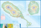
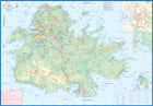
Street plans cover the town centres of Roseau and St John’s showing locations of selected hotels and other facilities. The Antigua side also includes an enlargement of the English Harbour area including Nelson’s Dockyard, plus panels with maps of Barbuda (1:25,000), Saint Martin/Sint Maarten, St. Barthélemy and St. Kitts and Nevis.
Publisert år: 2014
Innbinding: falset
Material: papir
Målestokk: 1:50000
Antigua; St. Kitts; Nevis
Ordinær pris 179,00 krOur latest version of Antigua is also a new title for ITMB, in that we are combining the Caribbean island nation with nearby St. Kitts and Nevis, with a small inset map for the lovely island of Barbuda. Side 1 is a very expansive and detailed map of Antigua, with a good inset map of St. John’s, the capital. At the southern end of the island is Nelson’s Dockyard, a historical remnant that serviced British naval ships for centuries, and is well-worth a visit.
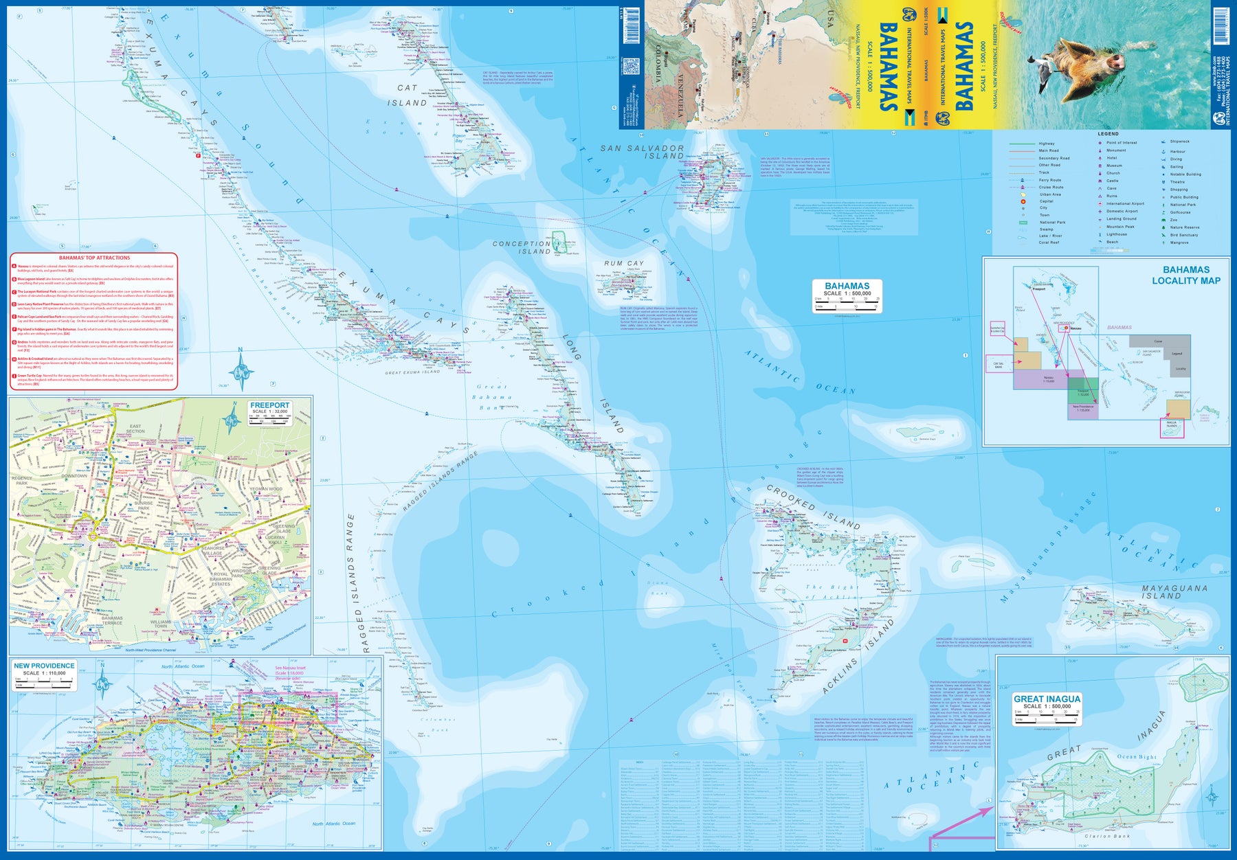
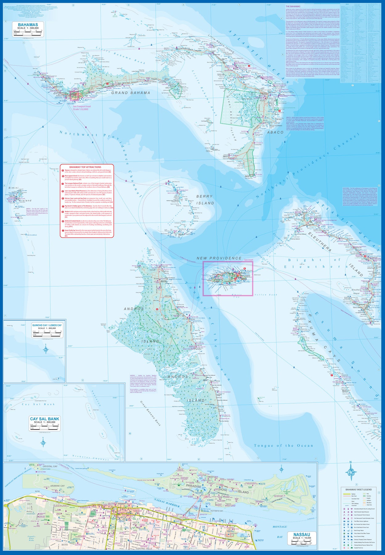
Bahamas
Ordinær pris 189,00 krITM har kart over hele verden og de spesialiserer seg på land litt utenfor allfarvei. Beliggenheten til landets nasjonalparker, historiske monumenter, de viktigste veiene o.L. Finner du inkludert i kartene. Samtlige landkart har ofte et bykart over hovedstaden.
Fra ITM: This fifth edition of our popular travel map to the many Bahamian islands shows a wealth of accommodations, beaches, and points of interest. Inset maps of Nasau and Freeport detail the two largest cities, and a special inset of New Providence Island, the most popular tourist destination, shows resorts and attractions that make this island so popular. As usual, we include a Top Attractions list of the 'must see' destinations.
Publisert år: 2023
Innbinding: falset
Material: plastpapir
Målestokk: 1:500,000
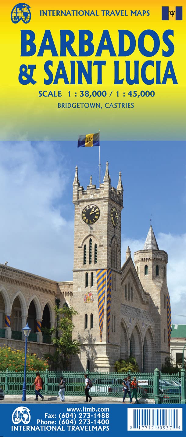
Barbados & Saint Lucia
Ordinær pris 189,00 krITM har kart over hele verden og de spesialiserer seg på land litt utenfor allfarvei. Beliggenheten til landets nasjonalparker, historiske monumenter, de viktigste veiene o.L. Finner du inkludert i kartene. Samtlige landkart har ofte et bykart over hovedstaden.
Fra ITM: Barbados and St. Lucia are adjacent Caribbean islands and are touristically important in their own rights, but are also frequently visited on the same cruise trip by a variety of cruise ship lines. Saint Lucia fills side 1 as one opens the map, with a comprehensive inset map of Castries, the capital. The interior of the mountainous island is mostly a rain forest and is largely inaccessible. The island has two airports and one cruise ship dock (at Castries) that provides access to inter-island ferries from St. Vincent, Barbados, Martinique, Dominica, and Guadeloupe, so the island is readily accessible internationally. Clusters of resorts abound at Marigot, Rodney Bay, Soufriere, and Vieux Port. A good highway links the far north to the far south. The other side of the sheet covers Barbados in fantastic detail, with an excellent inset map of Bridgetown, the capital. The island’s airport is east of the capital, and the focus for resorts is at St. Lawrence Gap, on the south coast, with another along the west coast, at Holetown. This island is more gently rolling countryside, with several scenic routes through and around the island. We have also included a Ten Top Attractions, including Sunbury Plantation (1660), St. Nicolas Abbey (1658), and Gun Hill Signal Station (1818). Both islands are loaded with history, attractions, and wonderful weather.
Publisert: Aug. 2021
Innbinding: falset
Material: vanntettpapir
Målestokk: 1:38,000/1:45,000
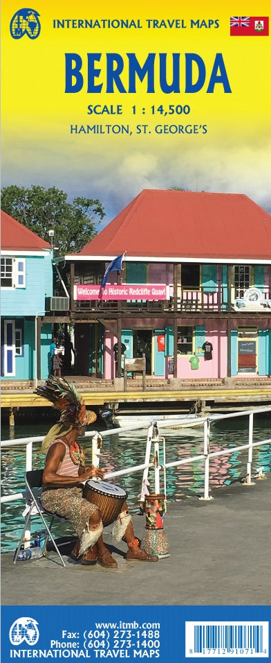
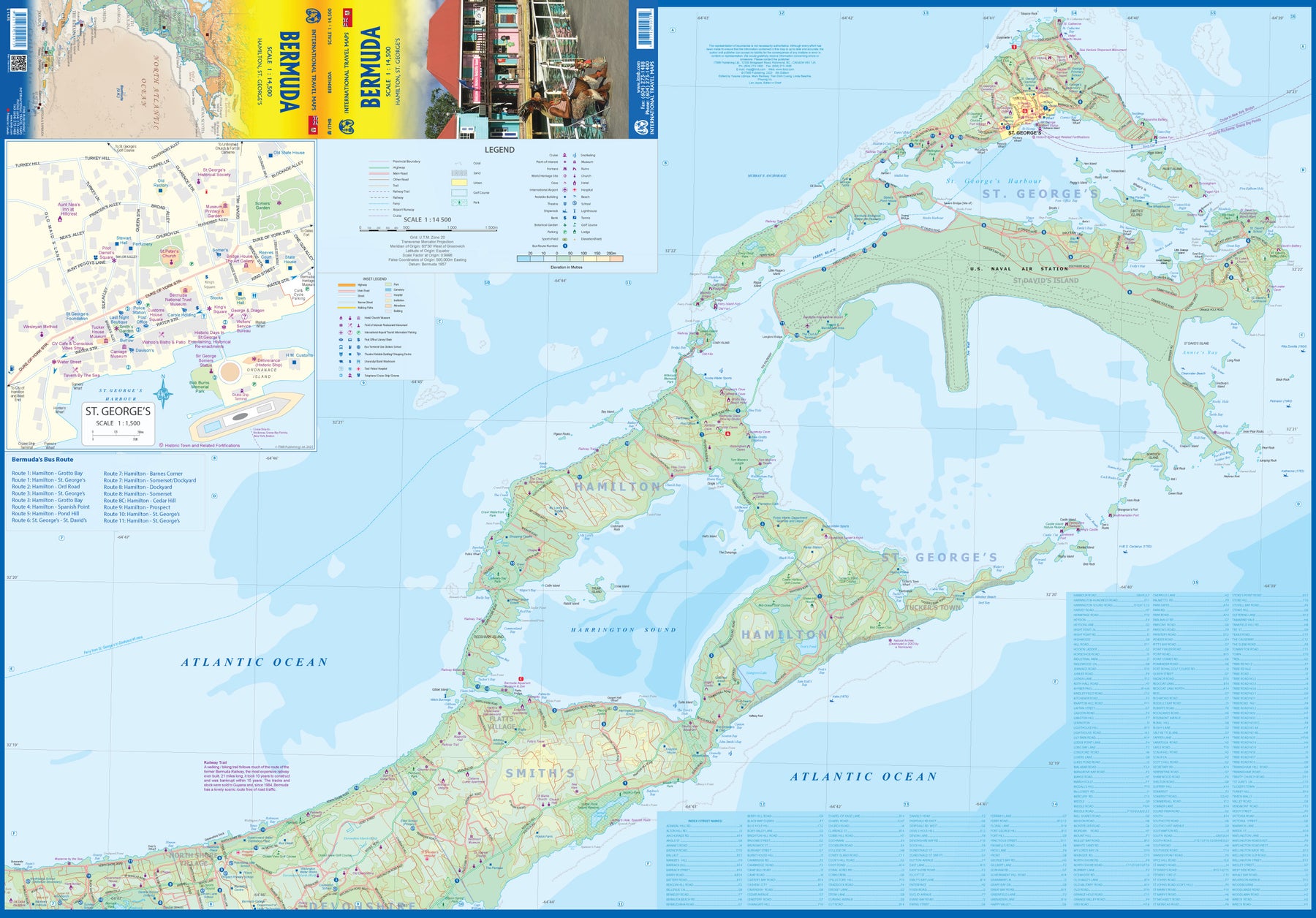
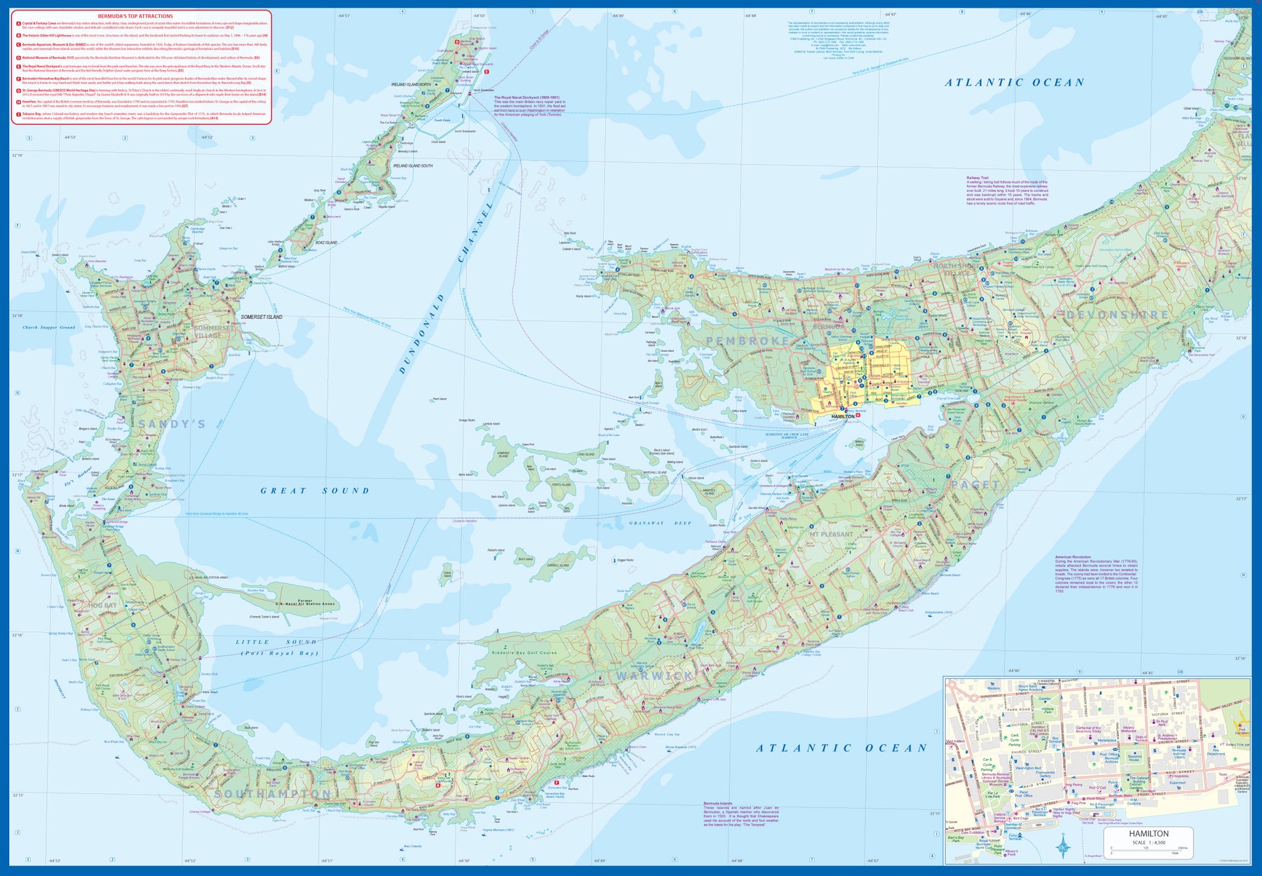
Bermuda
Ordinær pris 179,00 krBermuda is a lovely mid-Atlantic island far off the coast of South Carolina. It is full of colonial architecture and an ‘island’ way of life. Tourism is a key ingredient of the colony’s lifeblood and the island is very popular with cruise ships. There is ample accommodation for longer-term visitors, good roads, and much history. The airport was built by the US Navy during WW2 and is still a US Naval Air Station, but shares the runway with civil aviation.
The map includes an excellent inset of St. George’s, which still has its stocks close to the town hall, and another of Hamilton, the capital. This is where most cruise ships dock. For those with the time, the map shows the Railway Trail along the former route of the island’s now-defunct rail line. Lots to see; lots to do!
Boston
Ordinær pris 119,00 krLonely Planet City Map er slitesterkt og vanntett, med en hendig slipcase og et format som er lett å brette. Få mer ut av kartet og reisen din med bilder og informasjon om byattraksjoner, transportkart, reiseruteforslag, omfattende gate- og nettstedsindeks og praktiske reisetips. Med dette brukervennlige navigasjonsverktøyet i baklommen kan du virkelig komme til hjertet av din destinasjon!
Boston
Ordinær pris 99,00 krKart i postkortstørrelse. Folder seg ut som en popoutbok når du åpner dem. Fargerik turistinformasjon med kart over metro og busstraseer, landemerker og lignende. Veldig enkel å håndtere.
Publisert: 2023
Innbinding: pop
Material: papp, papir
California
Ordinær pris 189,00 krCalifornia, including Las Vegas and the Grand Canyon, at 1:800,000 on an indexed road map from Marco Polo Travel Publishing with prominent highlighting of interesting locations, enlargements and/or street plans for San Francisco, Los Angeles and Las Vegas, maps of seven national parks, descriptions of the regions 15 most interesting sights, etc. The map is double-sided with a very generous overlap; the south side extends beyond San Francisco to Sacramento, and the north side starts with the northern part of the LA conurbation.
Cartography is from the renowned German publishers MairDumont. Topography is presented by relief shading and spot heights, with plenty of names of mountain ranges, valleys, etc. Boundaries of national parks are marked, also of Indian Reservations and of restricted entry military areas. Road network clearly shows the numbers of interstate and main state roads, plus driving distances. Railway lines are included and local airports are marked. Locations of interest are highlighted, with separate colouring for towns or villages and for natural sites; 15 most interesting sights are cross-referenced to their descriptions in a booklet attached to the map cover and symbols indicate various other places of interest. Latitude and longitude lines are drawn at 1º intervals. The index is in the booklet and includes landscape features such as national parks, mountain ranges and peaks, rivers and lakes, etc.
Next to the map or in the booklet are: for Los Angeles, a map of the central part of its conurbation including the international airport, plus street plans of downtown, Hollywood and Beverly Hills; for San Francisco, an enlargement of the SF/Oakland Bay area including the international airport, plus street plans of downtown and of the Presidio - Golden Gate Bridge area; for Las Vegas an overview plan of the city plus street plans of downtown and the Strip with access to the international airport. The booklet also includes maps of the Bryce Canyon, Death Valley, Grand Canyon, Joshua Tree, King’s Canyon/Sequoia, Yosemite and Zion National Parks, a list of airports and UNESCO World Heritage sites, etc.
Canada
Ordinær pris 169,00 krCanada at 1:4,000,000 on a map from Marco Polo Travel Publishing with plenty of topographic information, plus a booklet attached to the map cover with an extensive index, six street plans, two enlargements of national parks, descriptions of 15 best sights, etc. Coverage extends to 74º north to include the whole of the Northwest Passage; a separate panel presents the rest of Arctic Canada at 1:12,000,000.
Cartography is from the renowned German publishers MairDumont. Topography is shown by relief shading with spot heights and plenty of names of mountain ranges, plateaux, etc. Locations of interest are prominently highlighted, with separate colouring for towns or villages and for natural sites; 15 selected places are cross-referenced to brief descriptions in the index booklet. Provincial parks or other protected areas as well as Indian Reservations are also marked. Adjoining regions of USA are similarly presented. Provincial and, in the US, state boundaries and time zones are marked. Road network varies according to the density population. Driving distances are shown in kilometres (in USA in miles). Railways and ferry routes are marked. The map has latitude and longitude lines at intervals of 2º.