52 produkter
0/13 Nevado Ojos Del Salado
Ordinær pris 259,00 kr0/3C Cordillera - Huayhuash
Ordinær pris 219,00 krPublisert år: 2008
Innbinding: falset
Material: papir
Målestokk: 1:50000
763 Peru
Ordinær pris 149,00 krACONCAGUA TREKKING MAP
Ordinær pris 299,00 krArgentina
Ordinær pris 189,00 krArgentina at 1:2,000,000 on an indexed, light, waterproof and tear-resistant road map with topographic and tourist information, published by Reise Know-How as part of their highly acclaimed World Mapping Project. The map is double-sided to provide the best balance between a good scale and a convenient size sheet.
The map divides Argentina north/south with an overlap between the sides. The north-eastern corner with the Missiones province and the Iguazu Falls is shown as an inset. Coverage of the southern half of the country includes the Chilean side of the Andes and the Magellan Straights. Altitude colouring with peak heights presents topography; swamps, salt flats and glaciers are also marked. Road network includes selected local tracks and indicates driving distances on main routes. Railway lines are included and local airports are marked. National parks and other protected areas are highlighted and a range of symbols mark various places of interest including selected campsites, beaches, vineyards, etc. Latitude and longitude lines are drawn at intervals of 1°. The map has an extensive index of localities. Map legend includes English.
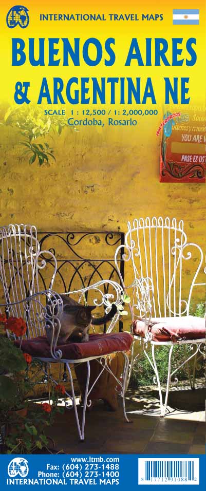
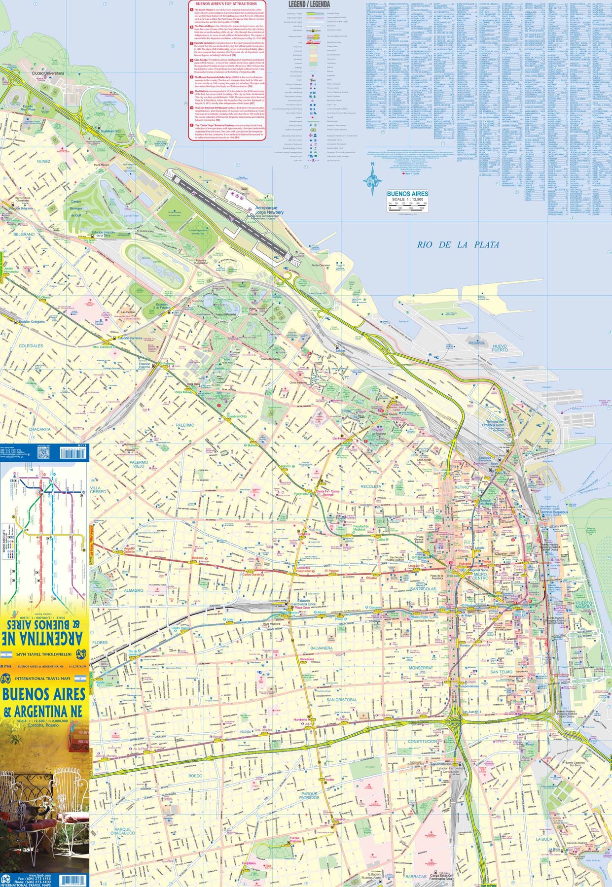
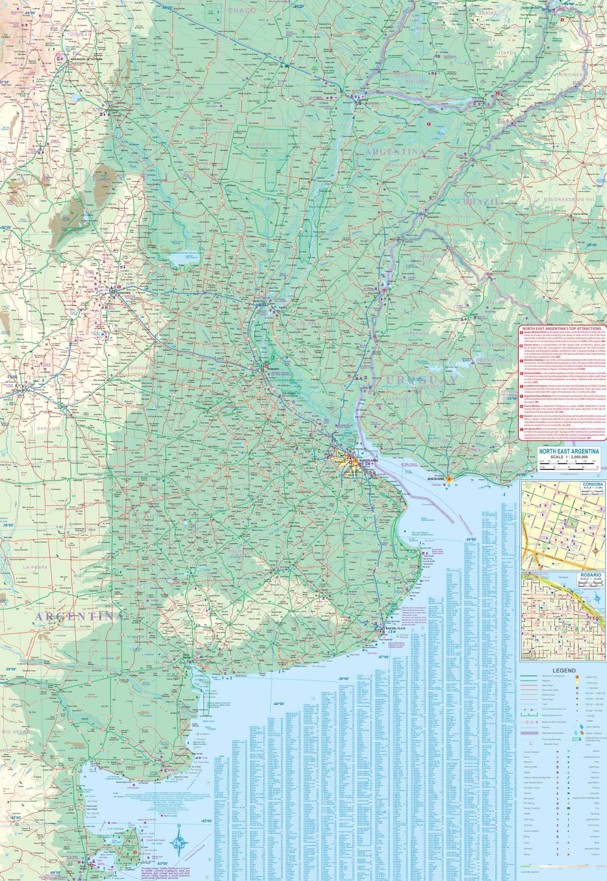
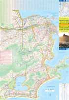
Argentina: Buenos Aires & Northeast
Ordinær pris 199,00 krThis version represents a thorough updating of this important Argentinean city. The subway lines are now clearly shown and the main shopping/pedestrian ways more clearly delineated. All three railway stations are shown, although rail services have largely been curtailed except for suburban usage. The cruise ship terminal has been added and the ferry crossing to Uruguay moved. La Recoleta cemetery has had pathways noted. The airport shown is only used for local flights, as the main international airport is quite far away from the city. It is noted on the second side of the map, which covers all of northeastern Argentina, most of Uruguay, and small portions of Brazil and Paraguay. No visit to Argentina would be complete without including Iguazu Falls or historic Cordoba, which are on this map. The regional map goes as far south as Puerto Madryn and includes such popular destinations as Bahia Blanca and Mar del Plata. Insets of Cordoba and Rosario are included.
Bolivia
Ordinær pris 189,00 krBolivia at 1:1,300,000 on an indexed, waterproof and tear-resistant road map with topographic and tourist information, published by Reise Know-How as part of their highly acclaimed World Mapping Project. The map is double-sided to provide the best balance between a good scale and a convenient size sheet.
Road and rail networks are easy to see on a clear base which presents topography by altitude colouring with contours, spot heights, glaciers, mountain passes and names of mountain ranges, geysers, salt pans and marshes. Road network indicates unsurfaced sections of main roads, includes local tracks, and gives driving distances on main and secondary roads. Ferry connections on Lake Titicaca are also marked. Internal administrative boundaries are shown with names of the provinces.
National parks and protected areas are marked and symbols highlight various places of interest, including campsites and selected hotels, archaeological remains, viewpoints, thermal spas, etc. The map has a grid with latitude and longitude at intervals of 1º and an extensive index of localities which lists national parks and nature reserves separately. Map legend includes English.
Brazil
Ordinær pris 169,00 krTysk kartserie med flotte kart på slitesterkt plastpapir.
Brazil at 1:3,850,000 on an indexed, waterproof and tear-resistant road map with topographic and tourist information, published by Reise Know-How as part of their highly acclaimed World Mapping Project, The map is double-sided to provide the best balance between a good scale and a convenient size sheet.
The map divides the country west/east, with the whole of the Brazilian Amazon Basin on one side and on the reverse the country south of the mouth of the Amazon and eastwards from Mato Grosso, with a generous overlap between the two sides. Coverage includes the whole of Paraguay, most of Bolivia with La Paz, Cochabamba and Oruro, and Peru north-eastern with Iquitos and south-eastern with Cusco and Arequipa.
Topography is shown by altitude colouring with contours and spot heights, graphics for swamps and salt pans, plus names of hill and mountain ranges, etc. Numerous tributaries of the Amazon, including many smaller rivers not directly flowing into it, are named. The map also shows boundaries of national parks and other protected area, plus numerous Indian reservations.
Road network indicates unsurfaced sections, includes local tracks, and gives driving distances on main and secondary roads. Railway lines are included and local airports are marked. Internal administrative boundaries are shown with names of the states. Symbols highlight various places of interest, including archaeological remains, viewpoints, thermal spas, etc. The map has a grid with latitude and longitude at intervals of 2º and an index of localities. Map legend includes English.
Publisert år: 2020
Innbinding: falset
Material: plastpapir
Målestokk: 1:3850000
Brazil: East Coast - Rio de Janeiro
Ordinær pris 169,00 krITM har kart over hele verden og de spesialiserer seg på land litt utenfor allfarvei. Beliggenheten til landets nasjonalparker, historiske monumenter, de viktigste veiene og lignende finner du inkludert i kartene. Samtlige landkart har ofte et bykart over hovedstaden.
Fra ITM: We are pleased to re-introduce our popular map of Rio for its third edition, and to include with it a detailed map of the south and east coasts of Brasil. Rio is a fascinating city. It recently hosted the Olympics and promised much in the way of infrastructural improvements. The core of the map is the Carioca region, close to the lower end of the tram line to the favelas. However, arriving visitors can now take the new subway from the airport to the city centre or south to the beach communities of Copacabana, Ipanema, and Leblon. The other side of the map covers much of developed Brasil, stretching from Sao Paulo in the lower left corner to Natal in the upper right of the sheet. It goes inland to Belo Horizonte and north along ordinary roads to Teresina on the Parnaiba River. The coastal highway through Salvador and Recife passes innumerable beaches and historic towns. Natal is a very popular beach area, with direct flights from Portugal. Altogether, an interesting map.
Brazil: South & East Coast
Ordinær pris 149,00 krITM har kart over hele verden og de spesialiserer seg på land litt utenfor allfarvei. Beliggenheten til landets nasjonalparker, historiske monumenter, de viktigste veiene o.L. Finner du inkludert i kartene. Samtlige landkart har ofte et bykart over hovedstaden.
Fra ITB: Brasil is such a large country that it needs two maps to cover it adequately. This map covers the country from the southernmost point to Sao Luis on the northern coast and inland as far as Brasilia. Scale 1:2,2 mio. This is where 80% of the country lives and where 95% of the tourists visit. The interior and Amazon region will be covered separately. This map includes separate inset maps of both Rio and Sao Paulo and shows the extensive motorway network of Brasil to good advantage. The top attractions of the region are noted, such as Iguazu Falls, Sugar Loaf, Brasilia, and Salvador.
Publisert år: 2018
Innbinding: falset
Material: Papir
Målestokk: 1:2200000
Chile
Ordinær pris 169,00 krChile at 1:1,600,000 on an indexed, waterproof and tear-resistant road map with topographic and tourist information, published by Reise Know-How as part of their highly acclaimed World Mapping Project. The map is double-sided to provide the best balance between a good scale and a convenient size sheet and presents this unusually long country in four sections. The two central panels also give good coverage of the Argentinian Andes, whilst the southern panel (southwards from approx. 46º, including the Chile Chico / Los Antiguos border crossing) extends to all the way to the Atlantic to cover southern Patagonia with Tierra del Fuego.
Topography is shown by altitude colouring with graphics for salt flats, glaciers and names of mountain ranges, peaks, etc. National parks and other protected areas are highlighted. Road network distinguishes between paved and unsurfaced roads and includes selected tracks. Driving distances are shown on main and selected secondary roads and border crossings are marked. Railway lines are included, local airports are indicated and in the fjords south of Puerto Montt ferry routes are marked. Internal administrative boundaries are shown with names of the provinces.
The map highlights towns, villages and natural features worth visiting. Symbols show various places of interest, including campsites and selected mountain shelters, beaches and surfing sites, skiing and fishing areas, archaeological remains, thermal spas, etc. The map has a grid with latitude and longitude at intervals of 1º and an extensive index of localities with a separate list of national parks and protected areas. Map legend includes English.
Chile
Ordinær pris 229,00 krNational Geographics Adventure-kart er laget for å møte behov på ulike eventyr. Kartet har nøyaktig topografi og viser i tillegg byer og tettsteder, samt tydelig detaljering av veinett - merket med avstander og betegnelser for motorveier og hovedveier, landeveier og stier. Fergeruter, flyplasser, fyr, jernbanestrekininger og andre reisenettverk er tegnet inn. Kartet er tosidig, vanntett og slitesterkt - ingen rift eller flisige hjørner her i gården.
Chile: Easter Island & Santiago
Ordinær pris 199,00 krITM har kart over hele verden og de spesialiserer seg på land litt utenfor allfarvei. Beliggenheten til landets nasjonalparker, historiske monumenter, de viktigste veiene o.L. Finner du inkludert i kartene. Samtlige landkart har ofte et bykart over hovedstaden.
Fra ITM: 4th edition 2015. Easter Island is so isolated that it is not certain whether it is part of Polynesia or an off-shoot of South America. Geologically, it is neither; just a volcanic lump in the vast expanse of the Pacific Ocean. Its original inhabitants probably came from Polynesia; since supplanted by migrants from Chile, which is the political authority governing the island. Regardless, it is an intriguing place, famous for the Maoi – giant heads originally raised to protect family holdings. These huge, mysterious heads rest in various locations on the island and are one of the wonders of the world. This map also includes a detailed map of Santiago de Chile, the capital of Chile, for the simple reason that all flights to Easter Island originate in that city, so everyone going to Easter Island needs a map of Santiago as well. This usage is merely for the convenience of visitors going to Easter Island.
Publisert år: 2020
Innbinding: falset
Material: papir
Målestokk: 1:24,000 / 12,500
Chile: Santiago & Northern Chile
Ordinær pris 179,00 krITM har kart over hele verden og de spesialiserer seg på land litt utenfor allfarvei. Beliggenheten til landets nasjonalparker, historiske monumenter, de viktigste veiene o.L. Finner du inkludert i kartene. Samtlige landkart har ofte et bykart over hovedstaden.
Fra ITM: The capital if Chile dominates the country. As locals, tell it, Santiago IS Chile; modern, cosmopolitan, and the main entry point for most visitors to Chile. The central banking and shopping district is well-served by four separate rapid transit lines and the map includes such attractions as parks, the railway station, the funicular, and the gondola ride. The reverse side of the map is an innovation for this title. The northern half of Chile is shown in two detailed portion maps, side by side. The far north, from the Peruvian border near Arica to Vina el Mar is shown on the first map, along with all crossings into neighbouring countries. The other map continues south from Vina del Mar/ Valparaiso to well south of Puerto Mont. This map would include Santiago, Talca, Concepcion, Temuco, and the Austral Highway as far south as Cochrane, which is close to the famous Laguna San Rafael National Park and its ice fields. Truly, a useful map!
Publisert år: 2019
Innbinding: falset
Material: papir
Målestokk: 1:12,500 / 770,000
Chile: South & Patagonia
Ordinær pris 199,00 krColombia
Ordinær pris 149,00 krITM har kart over hele verden og de spesialiserer seg på land litt utenfor allfarvei. Beliggenheten til landets nasjonalparker, historiske monumenter, de viktigste veiene og lignende finner du inkludert i kartene. Samtlige landkart har ofte et bykart over hovedstaden.
Fra ITM: Colombia is developing into one of the best touristic destinations in South America. It is easy to reach from North America and has invested heavily as a country in promoting tourism. We have been in the country twice since the last edition of our map was published, so this edition benefits from a wealth of new information and features. The map is printed on plastic waterproof paper for both durability and for standing up to usage in a humid tropical country. As a new feature, we have added a listing of the top attractions of Colombia, such as the salt cathedral of Zipaquira, the gold museum in Bogota (a must-see!!), and the Castilla overlooking Cartagena. The map includes excellent inset maps of Bogota, Cartagena, and Cali, as well as inset maps of San Andreas and Providencia Islands. Colombia is working hard to catch up on a huge backlog of infrastructural development, so expect to see road crews hard at work making all our updated highway information obsolete! It’s nice to see this beautiful country emerging as a revitalized powerhouse.
Colombia
Ordinær pris 169,00 krTysk kartserie med flotte kart på slitesterkt plastpapir.
Colombia & Ecuador
Ordinær pris 129,00 krGuyana; Suriname & French Guiana
Ordinær pris 169,00 krTysk kartserie med flotte kart på slitesterkt plastpapir.
Guyana, Suriname and French Guiana at 1:1,850,000on an indexed, waterproof and tear-resistant road map with topographic and tourist information, published by Reise Know-How as part of their highly acclaimed World Mapping Project. The map is double-sided to provide the best balance between a good scale and a convenient size sheet. The whole of Guyana is on one side, with Suriname and French Guiana on the reverse; disputed border areas are clearly marked.
Light altitude colouring with names of mountain ranges and peaks, plus spot heights, presents the topography. National parks and other protected area are highlighted. Road network includes unpaved, seasonal tracks. Distances are marked on main and secondary roads. and locations of petrol stations and border crossings are indicated. Symbols show various place of interest, including UNESCO World Heritage sites, beaches, etc. Also shown are internal administrative boundaries with names of the provinces. The map has a grid with latitude and longitude at intervals of 1º and an index of localities which lists national parks and nature reserves separately. Map legend includes English.
Publisert år: 2014
Innbinding: falset
Material: Plastpapir
Målestokk: 850000
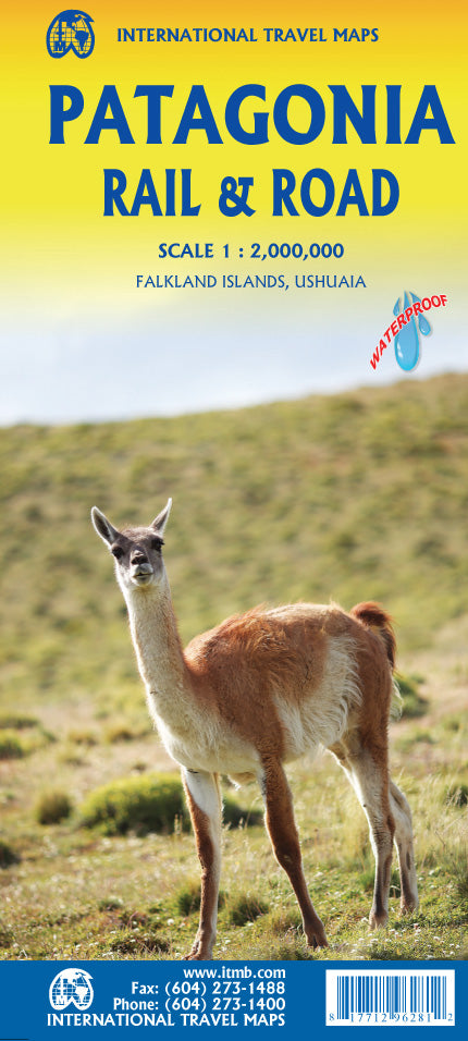
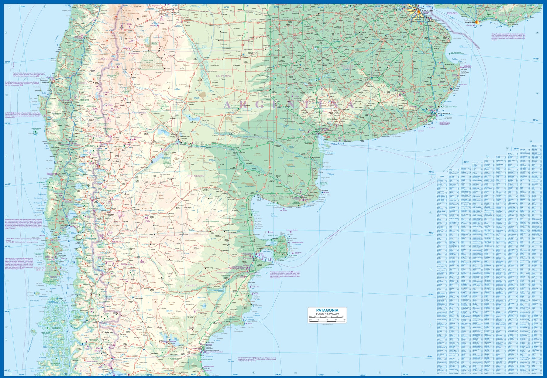
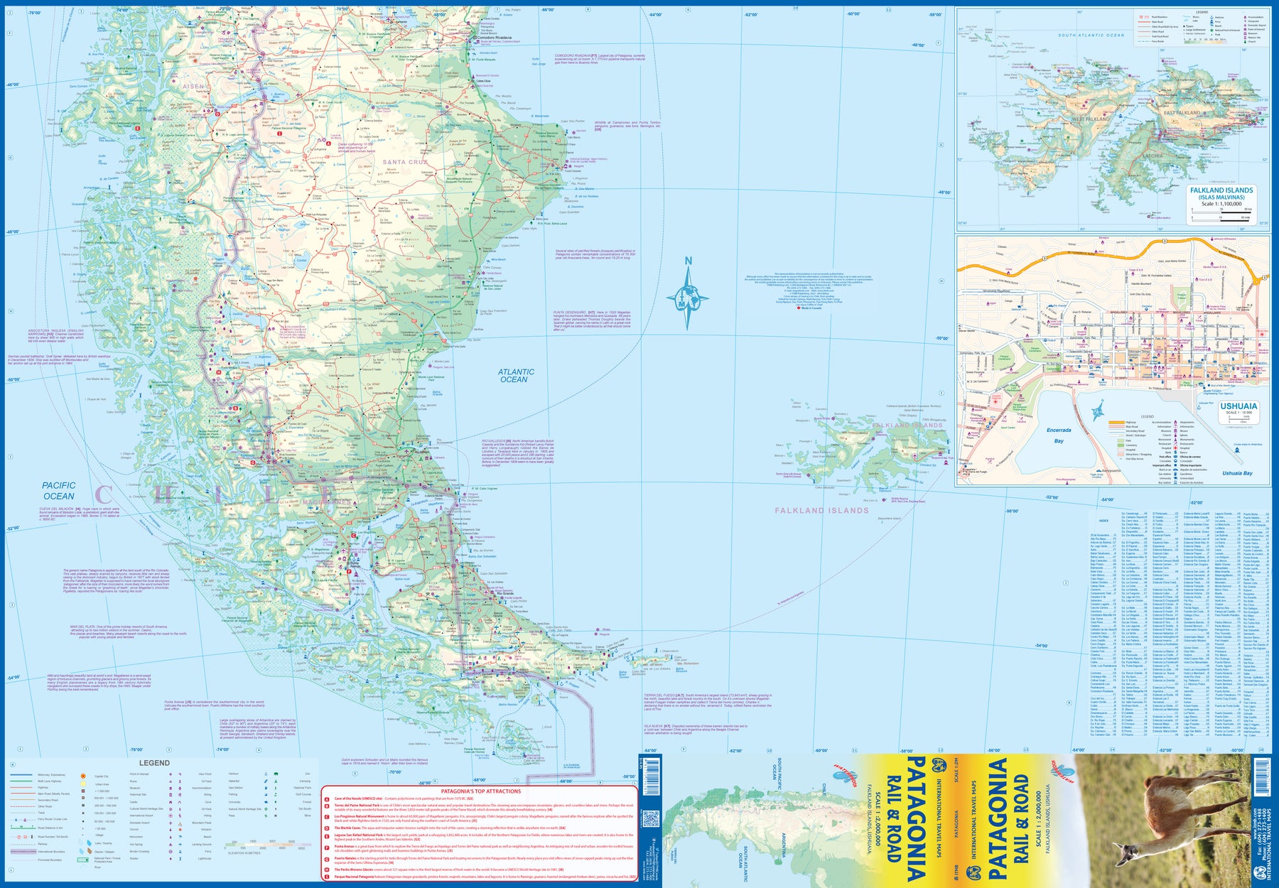
Patagonia Rail & Road
Ordinær pris 189,00 krITM har kart over hele verden og de spesialiserer seg på land litt utenfor allfarvei. Beliggenheten til landets nasjonalparker, historiske monumenter, de viktigste veiene og lignende finner du inkludert i kartene. Samtlige landkart har ofte et bykart over hovedstaden.
Fra ITM: Patagonia has changed dramatically in recent years. Argentina has finally invested in infrastructural improvements to make the region more accessible by paving roads, upgrading airports, building hospitals, encouraging tourism, and making exploration much more pleasant than when I first visited the region. By the shape of the southern third of South America, the map is best shown with the northern portion of Patagonia on one side and goes to the north of what is traditionally thought of as Patagonia to include the La Pampa region and Buenos Aires at the northernmost upper area of the map. As a result, all of Chile south of Conception is also shown. Highway 40, the 'spinal cord' of Patagonia, is now paved, or mostly so, making driving reasonably easy. There are rail lines in this northern region, and we have shown them, but I believe that all passenger service has been discontinued. The second side covers the Santa Cruz grasslands, the wonderful Chilean southern islands, and the very popular Tierra del Fuego portion of both countries. Most people do not realize that the Tierra region is an island, with access controlled by a Chilean ferry and border crossings into the Argentinian portion. Ushuaia, the most important city, is actually in the southern shore of the island, fronting on to the Beagle Channel. The southernmost point in South America is an island named after Hoorn, in old Holland, called Cape Horn in English. We even show the route tour boats use to get to Cape Horn from Ushuaia. The Falkland Islands are close enough to this southern tip of the continent to show on this map, and we have also included an expanded inset map to show the British colony in better detail. Just don't try to get there from Argentina! We have also included a detailed inset map of Ushuaia.
South America
Ordinær pris 249,00 krITM har kart over hele verden og de spesialiserer seg på land litt utenfor allfarvei. Beliggenheten til landets nasjonalparker, historiske monumenter, de viktigste veiene og lignende finner du inkludert i kartene. Samtlige landkart har ofte et bykart over hovedstaden.
Fra ITM: South America as a continent is fascinating. For many years, ITMB has provided this map, either in its original version of two single sided map or a double sided map, such as this. We spent a lot of time reviewing the artwork and updating information from more detailed maps. The resulting map is a considerable improvement on the previous edition. The print is remarkable clear and easy to read. Road categories, road numbers of highways, parks, major history and touristic information have all been updated. This is a fascinating continent, and this map is the definitive map of the continent
South America
Ordinær pris 119,00 krLonely Planet Planning Map er slitesterkt og vanntett, med en hendig slipcase og et format som er enkelt å brette. Få mer ut av kartet og reisen din med bilder og informasjon om toppattraksjoner i landet, reiseruteforslag, en transportguide, planleggingsinformasjon, temalister og praktiske reisetips. Med dette brukervennlige navigasjonsverktøyet i baklommen kan du virkelig komme til hjertet av din destinasjon!