243 produkter
243 produkter


243 produkter
Phuket
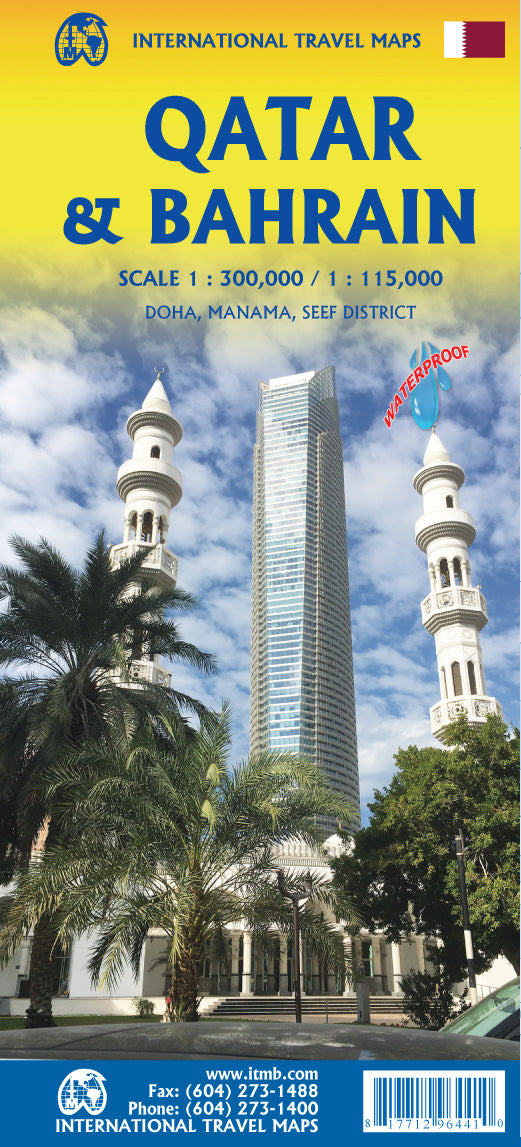
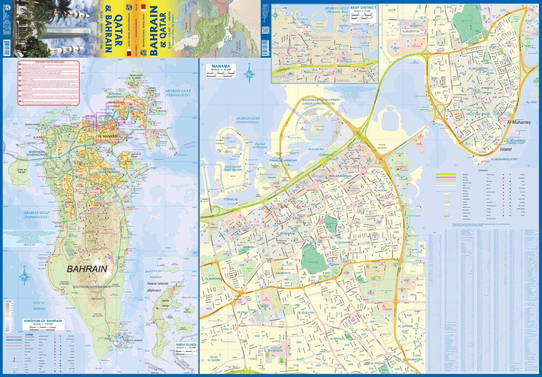
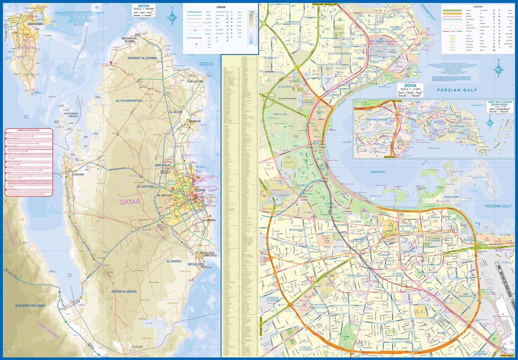
Ordinær pris 129,00 krQatar & Bahrain
Ordinær pris 179,00 krThe northern portion of the United Arab Emirates consists of a small peninsula (Qatar) and an island (Bahrain). Although these countries are not geographically significant in relation to their neighbours, they are enormously wealthy, thanks to oil, and have aspirations of grandeur. Qatar hosted the FIFA World Cup of soccer in November 2022. This is significant. Qatar, as a destination country, is now 'on the map'. Its capital, Doha, is quite well developed, with three Metro subway lines, motorways, and a sophisticated city centre dominated by superb high-rise architecture.
Just to the west, the island of Bahrain is just as wealthy, and just as likely to have ornate architecture, luxurious shopping arcades, and an extravagant lifestyle. Its capital, Manama, is growing very quickly, with large tracts of land being created out of shallow offshore sea areas. It also has Al Mukharqa, the fabulous old town, which is a market souk of narrow roadways to dream for. Both of these countries have been previously published by ITMB, but developments are occurring in both at such a rate that an updated map is essential to get around. This part of the world is fast becoming a desirable vacation centre as well as a business location and a favoured cruise ship destination; Qatar in particular. The map is printed on durable stone paper, as users will need to refer to it frequently to figure out where they are.
Saudi Arabia
Ordinær pris 229,00 krHighly tear-resistant and 100% waterproof map "Saudi Arabia" from the series world mapping project.
Travel know-how maps are characterized by particularly sturdy plastic paper, which can be written on like paper, even with a pencil. The cardboard envelope is removable, making it easy to put the card in any pocket. A protective cover is not required. The cartographic representation focuses on the most important information for travelers and is particularly easy to read. Instead of shading, colored layers of elevation are used.
Saudi Arabia & Kuwait
Ordinær pris 149,00 krITM har kart over hele verden og de spesialiserer seg på land litt utenfor allfarvei. Beliggenheten til landets nasjonalparker, historiske monumenter, de viktigste veiene o.L. Finner du inkludert i kartene. Samtlige landkart har ofte et bykart over hovedstaden.
Publisert år: 2013
Innbinding: falset
Material: papir
Målestokk: 1:1,750,000 / 1:390,000
Seoul
Ordinær pris 119,00 krShanghai
Ordinær pris 129,00 krShanghai
Ordinær pris 119,00 krLonely Planet City Map er slitesterkt og vanntett, med en hendig slipcase og et format som er lett å brette. Få mer ut av kartet og reisen din med bilder og informasjon om byattraksjoner, transportkart, reiseruteforslag, omfattende gate- og nettstedsindeks og praktiske reisetips. Med dette brukervennlige navigasjonsverktøyet i baklommen kan du virkelig komme til hjertet av din destinasjon!
Singapore
Ordinær pris 99,00 krSingapore
Ordinær pris 119,00 krMarco polo er svært detajerte kart som er praktiske og enkle i bruk. 7 klistremerker for å markere spesifikke steder gjør det enda enklere å planlegge reisen. Alle kartene inneholder en omfattende index for enkelt å finne frem.
Singapore Marco Polo City Map 2018: the ideal map for your trip.
Let the Marco Polo city map of Singapore guide you around this awe-inspiring city. Highly durable and waterproof, this handy, pocket-size Singapore map folds away easily and is always on standby to help when you're stuck.
Laminated finish - it feels like paper but it's waterproof, durable and tear-resistant! This hard-wearing, little pocket map of Singapore will withstand lots of folding and refolding.
Pocket size - the handy, light-weight, pocket-size format contains huge coverage of Singapore.
Easy to use - the super clear mapping in strong colours and clear text will help you navigate the city like a local.
Marco Polo Highlights are now included - the Top Ten sights are featured with a brief description and are marked on the map to help you get more from your trip.
Suggested tours - two inspirational itineraries are included, offering you ideas of what to see and how to plan your day.
Public transport maps - the centre of Singapore is easy to navigate on foot - but to enjoy all this city has to offer (and if your feet have had enough!) then look no further than the easy reference Singapore transport map.
Detailed scale - the scale is 1 : 12 000 showing you even the smallest of streets.
Shopping destinations, coffee shops, bars, restaurants and tourist information, are also listed and cross-referenced.
Ideal for short break, fly-drive and package holidays.
Extensive street index - perfect to help you find your destination easily and quickly.
Extended coverage - ideal for exploring slightly further afield.
Trust Marco Polo's clear mapping and thorough street index to guide you around the wonderful city of Singapore.
Publisert år: 2018
Innbinding: falset
Material: plast laminert
Målestokk: 1:12000
Skardu-hispar & biafo
Ordinær pris 189,00 krPublisert år: 1990
Målestokk: 1:200000
Southeast Asia
Ordinær pris 169,00 krNelles dekker store deler av kloden og er spesielt gode på den ikke-vestlige verden. Bykart er innsatt i regionskartene, og du får avstandstabeller og avmerkede attraksjoner som for eksempel nasjonalparker.
Southeast Asia
Ordinær pris 119,00 krLonely Planet Planning Map er slitesterkt og vanntett, med en hendig slipcase og et format som er enkelt å brette. Få mer ut av kartet og reisen din med bilder og informasjon om toppattraksjoner i landet, reiseruteforslag, en transportguide, planleggingsinformasjon, temalister og praktiske reisetips. Med dette brukervennlige navigasjonsverktøyet i baklommen kan du virkelig komme til hjertet av din destinasjon!
Sri Lanka
Ordinær pris 129,00 krSri Lanka
Ordinær pris 169,00 krSri Lanka at 1:500,000 on a light, waterproof and tear-resistant, indexed road map with altitude colouring and prominently highlighted places of interest, published by Reise Know-How as part of their highly acclaimed World Mapping Project.
Topography of the island is shown by altitude colouring, plus graphics for swamps, spot heights and names of mountain ranges; national parks and other protected areas are highlighted. In the coastal waters coral reefs are also marked. Clearly presented road network includes selected local tracks and gives driving distances on main routes. Railway lines are includes and local airports are marked. The map also shows internal administrative boundaries and names of the provinces. Names of larger towns are also given in the Sinhalese alphabet.
Symbols highlight numerous places of interest, including UNESCO World Heritage sites, temples and other religious buildings, beaches and diving sites, botanical gardens, etc. The map has latitude and longitude lines at 20’ intervals. The index is next to the map. Map legend includes English.
Street Map: Shanghai
Ordinær pris 149,00 krDiscover Shanghai by foot, car or bike using Michelin Shanghai City Plan (scale 1/17,500 cm). In addition to Michelin's clear and accurate mapping, this city plan will help you explore and navigate across Shanghai different districts thanks to its full index, its comprehensive key showing places of interest and tourist attractions, as well as practical information on public transport leisure facilities, service stations and shops!Discover the new range of Michelin City Maps* Write on Wipe off, Draw your route with a dry marker tipped pen, Erase with a damp cloth!* Plastic Format* Durable and convenient to use* Handy Compact, folds "free" for easy handling* Clarity and legibility of Michelin mapping:* Map of the city centre with identified tourist sites* Green Guide tourist sites* Smaller Map of whole city* Underground Map, with a detailed index.
Publisert år: 2019
Innbinding: Falset
Material: Plast
Målestokk: 1:15,000
Street Map: Tokyo
Ordinær pris 149,00 krDiscover Tokyo by foot, car or bike using Michelin Tokyo City Plan (scale 1/16,000). In addition to Michelin's clear and accurate mapping, this city plan will help you explore and navigate across Tokyo 's different districts thanks to its full index, its comprehensive key showing places of interest and tourist attractions, as well as practical information on public transport leisure facilities, service stations and shops!
Syria & Lebanon
Ordinær pris 199,00 krGizi Map er en serie presise kart med detaljer og opplysninger over både populære og mindre populære reisemål. Dekker ofte områder der få andre kartprodusenter dekker.
Taiwan
Ordinær pris 149,00 krNelles dekker store deler av kloden og er spesielt gode på den ikke-vestlige verden. Bykart er innsatt i regionskartene, og du får avstandstabeller og avmerkede attraksjoner som for eksempel nasjonalparker.
Taiwan & Taipei
Ordinær pris 179,00 krThe island of Formosa is friendly, attractively, interesting, safe, and an ideal travel destination. It is also a tad politically contentious, in that mainland China claims it as part of China. Be that as it may, Taiwan is an independent democracy at the moment, with its own government and institutions. Relations between China and Taiwan seem to be benign for the past dozen years or so, and flights from Beijing and Shanghai arrive daily, as do international flights.
Side one concentrates on the capital city of Taipei with an inset map of the extended urban area. The city is a typically crowded Chinese city, with the usual number of exceptionally high office towers (Taipei 101 was the tallest in the world a decade ago). Touristically, the city's main claim to fame is the museum housing the treasures of China brought to the island in 1949, as the Nationalist government led by Chiang Kai Shek moved the capital of China from Chungking (now Chongching), ending the civil war that had convulsed China for decades. The island itself is touristically very interesting.
Side two of the map contains the entire country at a very good scale. One can see at a glance that the western portion is fairly flat and thus is heavily populated, with three motorways joining Taipei to the cities of Taichung, Tainan, and Kaohsiung. An inset map of Tainan is included. I prefer the east coast, which is relatively undeveloped, and the mountainous interior. The road from Hsincheng thorugh the Taroka Gorge is a masterpiece of road construction. The resorts and hot springs of the interior are wonderful relaxing places to enjoy. Sun Moon Lake has several exotic temples and pagodas, and there are nearby aboriginal villages to explore. Further South, for those of an adventuresome inclination, is the port city of Taitung, and ferries to the outlying islands of Lanyu and Green. As will become increasing the case, this map is printed on crushed stone 'paper'. It is waterproof, durable, and tear-resistant.
The Mekong River
Ordinær pris 199,00 krTokyo
Ordinær pris 119,00 krLonely Planet City Map er slitesterkt og vanntett, med en hendig slipcase og et format som er lett å brette. Få mer ut av kartet og reisen din med bilder og informasjon om byattraksjoner, transportkart, reiseruteforslag, omfattende gate- og nettstedsindeks og praktiske reisetips. Med dette brukervennlige navigasjonsverktøyet i baklommen kan du virkelig komme til hjertet av din destinasjon!
Tokyo
Ordinær pris 99,00 krKart i postkortstørrelse. Folder seg ut som en popout-bok når du åpner dem. Fargerik turistinformasjon med kart over metro og busstraseer, landemerker og lignende. Veldig enkel å håndtere.
Tokyo
Ordinær pris 149,00 krFolded street and travel map in color. Scale 1:17,000. Legend includes sights, museums, churches, monuments, beaches, ski areas, Buddhist temples, Shinto shrines, hospitals, Subway, bus stations, parking, landing places, regional airports, waterfalls, national parks, hotels, markets. Includes inset map of Tokyo Bay & Shinagawa (1:19,000), Greater Tokyo (1:1,300,000) and Tokyo Subway Route map. Climate charts show the average daily temperatures, humidity, hours of sunshine and precipitation for each month.
Tsum Valley
Ordinær pris 199,00 krTsum Valley in central Nepal on an indexed contoured map at 1:100,000 from Shangri-La Design highlighting local trekking routes and places of interest, etc. Coverage extends roughly from the Budhi Gandaki River in the west across the eastern part of the Manaslu Conservation area, to just beyond Dunche in the east.
Topography is shown by contours at 40m intervals, plus colouring for woodlands, cultivated areas, glaciers, etc. The map shows local roads and distinguished between main trekking routes and minor trails. An overprint indicates various facilities in local villages, campsites, monasteries and other religious buildings, etc. The map is indexed for places, peaks and passes and had latitude and longitude margin ticks at 5’ intervals. Map legend includes English.
Addition information provided on the map or on its cover includes a table with relative oxygen rates at different altitudes, elevation profiles and hiking times for three main routes, plus general information about the area. All the text is in English.
Publisert år: 2009
Innbinding: falset
Material: papir
Målestokk: 1:100.000
Turkmenistan
Ordinær pris 199,00 krGizi Map er en serie presise kart med detaljer og opplysninger over både populære og mindre populære reisemål. Dekker ofte områder der få andre kartprodusenter dekker.
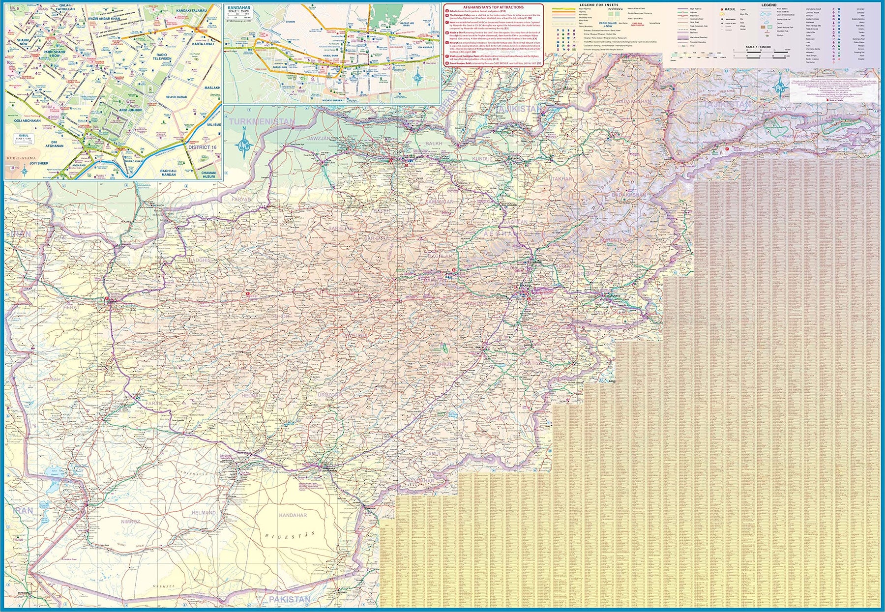
Turkmenistan & Afghanistan
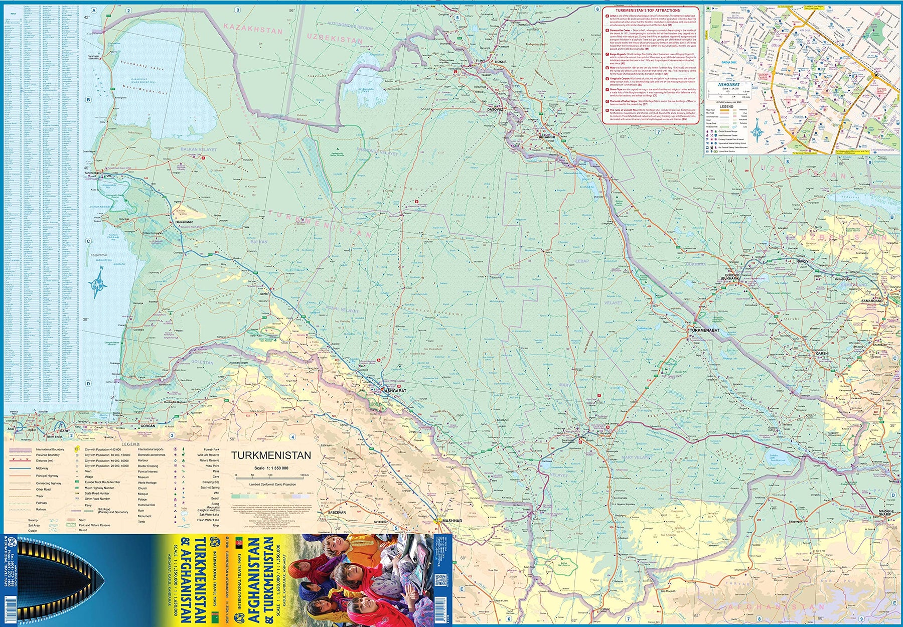
Ordinær pris 179,00 krThe world is changing as a result of a global pandemic, and ITMB has to change with it. We wish to keep all of our artwork available, but at a time of greatly reduced travel, we have been forced to combine two different countries that share a common border in order to justify printing either one. The two countries, Afghanistan and Turkmenistan, do share a common heritage, but a very different history. ITMB Publishes a separate map of the country, and a map of Kabul. The reason for this map is that it is our first ever map of just Turkmenistan, a former part of the USSR that broke away in the collapse of the Russian empire in 1990. The country has, however, not emerged from the Soviet way of thinking, and is authoritarian in its attitude. It is, fortunately, open to travel, and is slowly improving its facilities, so is to be encouraged.
The map includes a very good inset map of Ashgabat, the capital. The country stretches from the Caspian Sea to the Uzbek border and from Russia south to Iran and Afghanistan. We have also added eight Top Attractions, ranging from the World Heritage site of Konye to the ancient ruins of Nisa. We previously published this titles as part of a regional map of the ‘Stans’, but growing demand has justified its own map. We have also published a separate map of Uzbekistan and a separate three-country map of the other three countries, all of which are showing strong signs of touristic development. Turkmenistan is a country emerging as a future travel Mecca. Legend Includes: Roads by classification, Rivers and Lakes, National Park, Airports, Points of Interests, Highways, Main Roads, Zoos, Fishing, and much more...