


ITM har kart over hele verden og de spesialiserer seg på land litt utenfor allfarvei. Beliggenheten til landets nasjonalparker, historiske monumenter, de viktigste veiene o.L. Finner du inkludert i kartene. Samtlige landkart har ofte et bykart over hovedstaden.
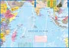
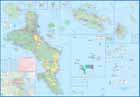
From ITMB: This is actually two brand new maps in one. This is a brilliant new map of the Seychelles archipelago and a first-ever map of the entire Indian Ocean. The islands of the Seychelles are too widely-spaced to portray except by as a series of ten insets. The main island is Mahe, which also houses the capital of Victoria (inset provided) and numerous resorts. Many of the islands have French names, reflecting the colonial to-and-fro that typified relations between Britain and France. Praslin, Curiuse, Falicite, La Digue, and Desroches are not names that bring immediate recognition, but they are the names of islands belonging to the Seychelles. The map shows dozens of resorts, as well as restaurants, touristic sites, historic sites, ferry docks, parks, and shopping areas. The reverse side covers the Indian Ocean as a marine map, with underwater ridges portrayed and countries portrayed politically in differing colours. The ocean nations of Comoros, Reunion, BIOT, Maldives, and Andaman/Nicobar Islands are likely only to be mapped in this context. It is an interesting map.
Publisert år: 2022
Innbinding: falset
Material: papir
Målestokk: 1:45,000 / 10,000,000