Filter
57 produkter
57 produkter
Utsolgt
Caucasus
ITM
169,00 kr
Utsolgt
Everest & Himalaya
ITM
169,00 kr
Utsolgt
India
ITM
149,00 kr
Utsolgt
Iran & Tehran
ITM
149,00 kr
Utsolgt
Israel & Palestine
ITM
169,00 kr
Utsolgt
Japan: Central
ITM
189,00 kr

Bahrain & Manama City
Ordinær pris 149,00 kr/
Mva inkludert
Frakt beregnes i kassen.
ITM har kart over hele verden og de spesialiserer seg på land litt utenfor allfarvei. Beliggenheten til landets nasjonalparker, historiske monumenter, de viktigste veiene o.L. Finner du inkludert i kartene. Samtlige landkart har et bykart over hovedstaden.
From ITMB: Bahrain road map at 1:115,000 plus an indexed street plan of Manama City at 1:10,000 from ITMB indicating both developments in progress and future plans including the train line and the causeway linking Bahrain with Qatar. All place names are shown in Latin alphabet only.
The map is divided in two large panels. Bahrain is presented at 1:115,000 with the island’s road network including dirt tracks, proposed Gulf States Railway Line, airports, oil rigs and pipelines, as well as places of interest such as the Grand Prix circuit, Bahrain Fort World Heritage site, etc. Topography is shown by altitude colouring with spot heights and graphics for salt flats. Latitude and longitude lines are shown at 5’ intervals. The map is not indexed. Hawar Islands are included as an inset.
The larger panel covers Manama with Muharraq at 1:10,000 with its index listing both street names and quadrants. The plan indicates main traffic routes and highlights various services, facilities and places of interest, including tourist accommodation, shopping centres, museums and mosques, etc. An inset extends coverage beyond the Lulu Island (Reef Island) development to include the Seef District.
Publisert år: 2010
Innbinding: falset
Material: papir
Målestokk: 1:115000

Bangladesh & India East
Ordinær pris 149,00 kr/
Mva inkludert
Frakt beregnes i kassen.
ITM har kart over hele verden og de spesialiserer seg på land litt utenfor allfarvei. Beliggenheten til landets nasjonalparker, historiske monumenter, de viktigste veiene o.L. Finner du inkludert i kartene. Samtlige landkart har ofte et bykart over hovedstaden.
Fra ITM: Bangladesh at 1:750,000 on an indexed map from ITM, with street plans of central Dhaka and Chittagong, plus on the reverse a road map of north-eastern India with a street plan of Kolkata plus an enlargement of the city’s environs.
On one side is an indexed map of Bangladesh at 1:750,000. Distances are shown on main roads and railway lines are included. The map also shows administrative borders with names of the provinces. Town names are annotated with icons indicating that facilities and/or places of interest can be found there. The map also highlights various other interesting sites. Latitude and longitude lines are drawn at 30’ intervals. The map is accompanied by street plans of central Dhaka and Chittagong, highlighting various facilities and places of interest, plus notes about the country, etc.
On the reverse is an indexed road map of North-Eastern India and eastern Nepal at 1:1,500,000, extending in India south-west to Sambalpur and Bhubaneshwar and within Nepal west to Pokhara. Please note that coverage of Bangladesh on that side of the map is incomplete, with the central part of the country blocked by the index. The map shows the regions road and rail connections, local airports, state boundaries, and various places of interest. Topography is indicated by altitude colouring in feet, although peak heights are given in metres. Latitude and longitude lines are drawn at 1°intervals. An enlargement shows the environs of Kolkata (Calcutta) in greater detail, and also included is a street plan of central Kolkata highlighting important buildings, various facilities, etc.
Publisert år: 2013
Innbinding: falset
Material: papir
Målestokk: 1:1500000

Borneo: Sarawak; Sabah & Brunei
Ordinær pris 149,00 kr/
Mva inkludert
Frakt beregnes i kassen.
ITM har kart over hele verden og de spesialiserer seg på land litt utenfor allfarvei. Beliggenheten til landets nasjonalparker, historiske monumenter, de viktigste veiene o.L. Finner du inkludert i kartene. Samtlige landkart har ofte et bykart over hovedstaden.
Publisert år: 2012
Innbinding: falset
Material: papir
Målestokk: 1:620000

Cambodia & Mekong Delta
Ordinær pris 169,00 kr/
Mva inkludert
Frakt beregnes i kassen.
ITM har kart over hele verden og de spesialiserer seg på land litt utenfor allfarvei. Beliggenheten til landets nasjonalparker, historiske monumenter, de viktigste veiene o.L. Finner du inkludert i kartene. Samtlige landkart har ofte et bykart over hovedstaden.
Fra ITM: Tourism to Cambodia is growing so quickly that we felt it necessary to bring back the country as its own map, instead of being combined with Laos. However, the entire country fits very nicely on one side of a map sheet, so we have combined it with neighbouring Vietnam’s Mekong Delta map. There are two treasures in Cambodia: the Angkor Wat complex of temples near Siem Riep, and the capital of Phnom Penh. Cambodia became extremely destabilized by the Vietnam War in the 1960s, leading to a rebellion that placed the murderous Khmer Rouge in charge. This led to massive atrocities and de-populated all towns, killing millions. Siem Riep is a thriving touristic city, and UNESCO manages the Angkor complex very well. The capital has mostly recovered, but still retains the sleepy colonial atmosphere of the French era. River boats ply the Mekong River and transport visitors to Vietnam, where the river divides into nine mouths to flow into the ocean. That brings us to the second side of the map and the area known as the Mekong Delta. This is a very useful map in its own right. The delta is extremely rich agricultural land with numerous canals carrying water to countless rice paddies. The map also provides a link between Phnom Penh and Saigon/HCM City, which has now grown to nine million people.
Legend Includes:
Roads by classification, Rivers and Lakes, National Park, Airports, Points of Interests, Mining, Highways, Main Roads, Zoos, Fishing, , and much more...
Publisert år: 2019
Innbinding: falset
Material: Vanntett Papir
Målestokk: 1:800000/410000

Caucasus: Azerbaijan & Armenia
Ordinær pris 149,00 kr/
Mva inkludert
Frakt beregnes i kassen.
ITM har kart over hele verden og de spesialiserer seg på land litt utenfor allfarvei. Beliggenheten til landets nasjonalparker, historiske monumenter, de viktigste veiene o.L. Finner du inkludert i kartene. Samtlige landkart har ofte et bykart over hovedstaden.
Fra ITM: Armenia and Azerbaijan at 1:430,000 on a double-sided, indexed map from ITMB, with each country accompanied by a street plan of its capital. Diverse ethnography of the region is indicated on an inset.
On one side is Armenia with most of Nagorno-Karabakh, plus the Nakhchivan Autonomous Republic of Azerbaijan and much of Georgia including Tbilisi. The reverse, with a small overlap, is the remainder of Azerbaijan. Topography of the region is shown by altitude colouring in feet, with heights of peaks given in metres (and not in feet as indicated in the map legend). Mountain passes are annotated with months when passable. Swamp areas are marked and national parks or protected areas highlighted. The map shows the region’s road and rail networks, including selected seasonal tracks, and indicates local airports. Symbols highlight various places of interest: historical sites, beaches, winter sport areas, etc. All place names are in the Latin alphabet only. Latitude and longitude lines are drawn at 1° intervals. Each country has a separate index. Street plans of central Yerevan and Baku name main streets and highlight various places of interest including selected foreign embassies. Also provided is an inset showing the distribution of various ethnographic groups.
IMPORTANT - PLEASE NOTE: international and provincial boundaries are not marked precisely enough to give a clear picture of the current political situation in the region, including enclaves and border crossings.
Publisert år: 2016
Innbinding: falset
Material: Papir
Målestokk: 1:430,000


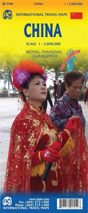
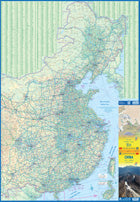
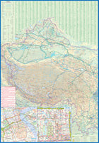
China
Ordinær pris 199,00 kr/
Mva inkludert
Frakt beregnes i kassen.
This edition is printed on waterproof, tear-resistant paper, and has a new cover picture showing a portion of the Great Wall. A cursory glance at the map will show an incredible number of motorways. We still show some as being under construction, but updating the road network is now essentially completed. The amazing rapid rail network is now also essentially complete and all such train lines are noted on the map in a red-dashed format. Inset maps of Beijing and Shanghai are shown on side 2, as well as a list of Top Attractions.
We continue to show contentious political disputed territories based on practical administrative control, so India's northeast is shown as being under India's control, whereas parts of the northwest are shown under Chinese control. Taiwan is shown, simply because it is geographically close to mainland China. We do not wish to be drawn into the question of the future status of the island; it is independently operating, as it has been doing since 1949.
- Publisert: 2022
- Innbinding: Falset
- Materiale: Vanntett papir
- Målestokk: 1:3,800 000

China: Beijing & The Great Wall
Ordinær pris 149,00 kr/
Mva inkludert
Frakt beregnes i kassen.
ITM har kart over hele verden og de spesialiserer seg på land litt utenfor allfarvei. Beliggenheten til landets nasjonalparker, historiske monumenter, de viktigste veiene o.L. Finner du inkludert i kartene. Samtlige landkart har ofte et bykart over hovedstaden.
4th edition January 2015. Beijing in scale 1:23.000 The other side of the map is just as interesting. It covers the portion of the Great Wall of China that all visitors see, near Badaling (scale 1:280.000), and also shows those sections that have disappeared over time, or have fallen into disrepair. As well, the famous Ming tombs of former emperors is also shown, as well as the Marco Polo bridge on the western edge of Beijing, so-named in honour of the famous trader/explorer who set out from this point on his return trip to Europe. This time, we have printed our Beijing/great Wall map in durable ITM plastic; printed double-sided.
Publisert år: 2015
Innbinding: falset
Material: plastpapir
Målestokk: 1:280000

China: Hong Kong & Region
Ordinær pris 149,00 kr/
Mva inkludert
Frakt beregnes i kassen.
ITM har kart over hele verden og de spesialiserer seg på land litt utenfor allfarvei. Beliggenheten til landets nasjonalparker, historiske monumenter, de viktigste veiene o.L. Finner du inkludert i kartene. Samtlige landkart har ofte et bykart over hovedstaden.
Fra ITM: 4th edition 2016. Hong Kong is a double-sided map in scale 1:10.000/1:60.000, printed on waterproof paper.A street plan of Hong Kong with Kowloon at 1:10,000 and on the reverse a road map of the HK Special Administrative Region at 1:60,000, plus a diagram of the transport network. The street plan show Hong Kong and Kowloon at 1:10,000 with colouring for the main traffic arteries, very clear presentation of the highway junctions, and marking for one way streets. Where appropriate, MTR and KCR stations are shown with multiple entrances/exits, and the map also shows the double-decker tram line, the Mid-Levels Escalator and the ferry connections across the Victoria Harbour and Kowloon Bay. The plan also shows pedestrianized streets and those with staircases in the hilly part of the Hong Kong Island. Various places of interest and facilities are highlighted, including selected hotels. On the reverse is an indexed road map of the Hong Kong SAR at 1:60,000, extending north to Shenzehen. Altitude colouring shows the topography. Railway and ferry connections are marked and numerous places of interest are highlighted. On both sides place names are given in the Latin alphabet only, with on the road map selected location also shown in Chinese. The map includes a diagram of the transport network.
Publisert år: 2016
Innbinding: falset
Material: plastpapir
Målestokk: 1:10000/60000

China: Shanghai & Southeast
Ordinær pris 169,00 kr/
Mva inkludert
Frakt beregnes i kassen.
ITM har kart over hele verden og de spesialiserer seg på land litt utenfor allfarvei. Beliggenheten til landets nasjonalparker, historiske monumenter, de viktigste veiene og lignende. Finner du inkludert i kartene. Samtlige landkart har ofte et bykart over hovedstaden.
Fra ITM: 4th Edition Although Shanghai is not the largest city in China (that record belongs to Chongching), at 24,000,000 plus people, it is an enormous area. It is one of the best-known of china's mega-cities, situated on the Huangpu River, close to the ocean. The map covers the urban area from the main railway station in the north to the Xuhui area in the south and from East China university campus to the Maglev station in the east. An inset map shows the Maglev route to Pudong International Airport. The touristic core of Shanghai is portrayed in excellent detail. The Bund, along the riverfront, is well-known, all the streets in the Old Town are shown, as is the main shopping district along Nanking Road. Ferry routes along the river are shown, as well as a good selection of hotels. The various rapid transit lines are also shown. The reverse side of the map portrays most of eastern China, from Beijing to Hong Kong to Xi'an in the west. China is evolving quite rapidly and has constructed a complex series of motorways and super-speed train lines in recent years. These are all shown in very good detail. The map also includes the island of Taiwan, claimed by China, but independent. The regional map covers the area of interest for the vast majority of visitors to China, including two dozen mega-cities of more than 5 million people each.
- Publisert: 2021
- Innbinding: Falset
- Materiale: Plastpapir
- Målestokk: 1:16,000 / 1:2,500,000

China: South
Ordinær pris 149,00 kr/
Mva inkludert
Frakt beregnes i kassen.
ITM har kart over hele verden og de spesialiserer seg på land litt utenfor allfarvei. Beliggenheten til landets nasjonalparker, historiske monumenter, de viktigste veiene o.L. Finner du inkludert i kartene. Samtlige landkart har ofte et bykart over hovedstaden.
Fra ITM: 1st edition October 2015. This map in scale 1:3 mio. concentrates on the part of China from Shanghai south and all the way west to Lhasa and includes Taiwan and Hainan Island. We are not trying to make any sort of political comment here, but geographically, both Tibet and Taiwan fall within the area of coverage and are both included for this reason alone. Inset maps of Hong Kong, Guangzhou (1:850.000) and Shanghai. Legend Includes: Roads by classification, Points of Interest, National Parks, Airports, Golf Courses, Beaches, Campsites, Waterfalls, Viewpoints, Churches, Surfing/Scuba Diving Spots, Fishing Spots, Hospitals, harbours/Ports, Lighthouses, Museums, Monuments, Caves, Mosques, Mountain Peaks, Botanic Gardens, Wildlife Sanctuary, Zoos, Sports Fields, and much more.
Publisert år: 2015
Innbinding: falset
Material: Plastpapir
Målestokk: 1:3000000

China: South & Guangzhou
Ordinær pris 149,00 kr Salgspris 119,00 kr Spar 20%/
Mva inkludert
Frakt beregnes i kassen.
China, as a country, is very popular with travellers. However, China is also a very large geographical entity and showing the entire country on one map results in a scale that reduces the amount of information that can be shown. The most visited part of the country is the south, with rapid train access from Hong Kong and major airports at Guangzhou and Shanghai. Travel to China is also increasing as more international airports are opened. The regional map covers one side of this double-sided map; the other contains an updated map of Guangzhou (formerly Canton). Lan and I visited this city in February and were surprised at how open and modern the city is. In comparison with Beijing, the political overtones are much reduced, and Sun Yat Sen is the hero. The city is also a major train hub, with two major stations handling traffic, and six bus stations arranging transportation to nearby cities.
- Publisert: 2015
- Innbinding: Falset
- Materiale: Papir
- Målestokk: 1:3 000 000, 1:15 000

India: Delhi & North
Ordinær pris 149,00 kr/
Mva inkludert
Frakt beregnes i kassen.
ITM har kart over hele verden og de spesialiserer seg på land litt utenfor allfarvei. Beliggenheten til landets nasjonalparker, historiske monumenter, de viktigste veiene o.L. Finner du inkludert i kartene. Samtlige landkart har ofte et bykart over hovedstaden.
Fra ITM: Delhi is not only one of the largest cities in the world, it is the principal gateway into India. It is also the capital of modern India, and was the capital of the Mughal dynasty from the mid-1600s. As a result, it is a blend of history, the Raj era, and post-independence chaos. The Red Fort is a UNESCO World Heritage site, and the Tughlaqabad fortress ruins, dating from the 1300s, stretch for six kilometers. India’s largest mosque is located here, as well as its largest Hindu temple and the largest Sikh temple. In fact, Delhi is a city of religious buildings. The reverse side of the sheet is new to this edition, covering much of central northern India and is perfect for making short tours of the region from Udaipur in the southwest to Srinagar in Kashmir/Jammu and historic Lucknow, site of the siege during the Mutiny, in the east. Jaipur and Agra (with its world famous Taj Mahal) is also on the map, as are dozens of other interesting cities and cultural sites. Printed on waterproof paper, this map is both informative and full of interesting tidbits of information. Delhi 1:30.000, Northern India 1:3.000.000.
Publisert år: 2018
Innbinding: falset
Material: papir
Målestokk: 1:30000/3000000

Indonesia
Ordinær pris 149,00 kr/
Mva inkludert
Frakt beregnes i kassen.
ITM har kart over hele verden og de spesialiserer seg på land litt utenfor allfarvei. Beliggenheten til landets nasjonalparker, historiske monumenter, de viktigste veiene o.L. Finner du inkludert i kartene. Samtlige landkart har ofte et bykart over hovedstaden.
Fra ITM: A map of Indonesia, which offers an overall view of this vast archipelago, over 700 islands. It also shows all sea links between the different îslands, the traveler can move from island to island. Scale 1:2,4 mill. The legend includes: The various roads, airports, seaport, hiking, national park, nature reserve, wildlife sanctuary, marine reserve, Beach, Water sports, Fishing, Coral Sand Volcano, Monument and more. 5th edition 2018.
Publisert år: 2018
Innbinding: falset
Material: Plastpapir
Målestokk: 1:2400000

Iraq & Baghdad
Ordinær pris 149,00 kr/
Mva inkludert
Frakt beregnes i kassen.
ITM har kart over hele verden og de spesialiserer seg på land litt utenfor allfarvei. Beliggenheten til landets nasjonalparker, historiske monumenter, de viktigste veiene o.L. Finner du inkludert i kartene. Samtlige landkart har ofte et bykart over hovedstaden.
Fra ITM: Iraq and Baghdad Travel Reference Map 4th Ed. (2nd for Baghdad) 1:1,200,000/125,000 – As Iraq gradually settles down, it will be possible for visitors to return in bulk. At the moment, only the Kurdish-controlled north could be considered ‘safe’, and tourism is growing. Two international airports already receive planeloads of visitors from Europe, and the border with Turkey is one of the busiest crossing points in the world. ITMB has been involved with mapping Iraq since before the first Gulf War, when we provided the only map of Iraq then in print. By the time of the second war, commonly called the Iraq War (or George Bush’s Folly, if you prefer), ITMB had a more sophisticated map, but one that had to be prepared under extremely trying circumstances. The third edition came out after the ‘allies’ (read Americans) had occupied the country, but before it was safe for anyone but the most foolhardy to go there. This edition updates and improves upon all earlier editions. In addition, we have replaced our separate map of Baghdad with new artwork that is both up-to-date and will be responsive to changes as they unfold. Make no mistake – Iraq is going to be a force to be reckoned with in the near future, as a bulwark against Iran, if for no other reason, but the country we call Iraq is undergoing some fundamental changes, and we want to be able to portray those new directions as they take place; hence the urgent need we felt to update the artwork for both the country and its capital simultaneously. This is one of the most important maps that ITMB produces. Not its most popular, to be sure, but by the measurement of significance, there are few places in the world more pivotal to the world’s unfolding historical development. Saddam Hussein was right: the Mother of All Battles was about to be undertaken. Little could he know that he was only a bit player in the drama that swept everything he believed in into the dustpan of history and transformed the entire Middle East, but the past several years really have seen the Mother of All Battles, and it isn’t over yet – not by a long shot, and not being fought in Iraq any more. Enjoy the map; I think it’s quite good. Printed with Iraq on one side and Baghdad on the other, and including a large inset of the highway network surrounding the capital.
Publisert år: 2011
Innbinding: falset
Material: papir
Målestokk: 1:1200000


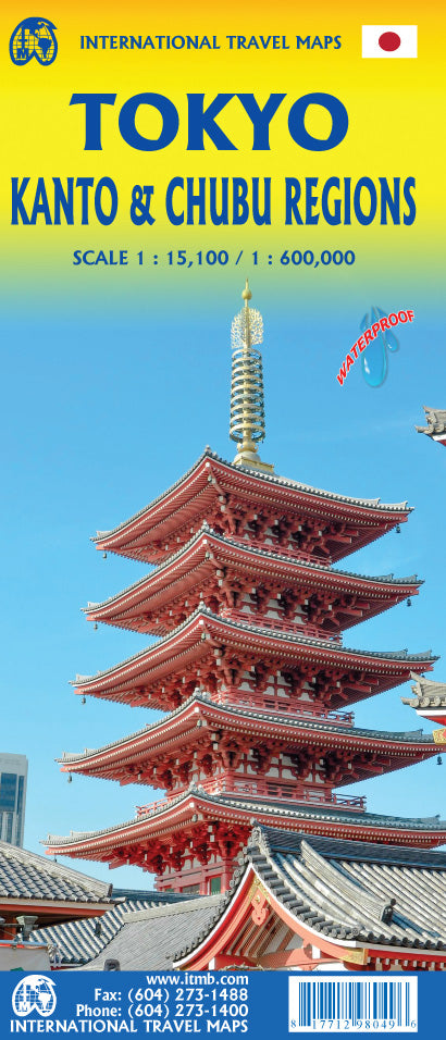
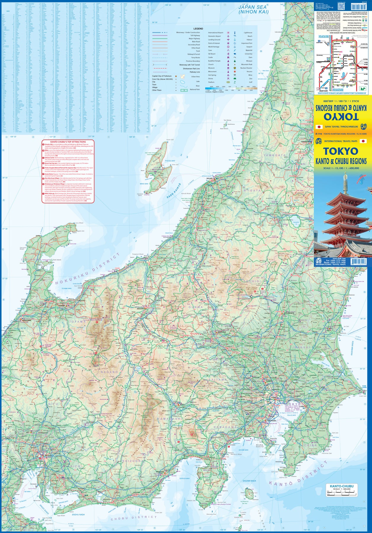
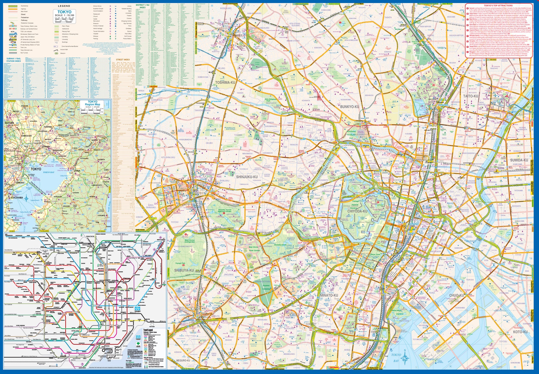
Japan: Tokyo (Kanto & Chubu Regions)
Ordinær pris 179,00 kr/
Mva inkludert
Frakt beregnes i kassen.
Tokyo is one of the most populous cities in the world, so it is very difficult to capture all of it on one map sheet. The areas of touristic interest tend to exist in a relatively small portion of the metropolis, essentially from the Shibuya and Shinjuku shopping areas in the west to the Asakusa temple complex in the east. All the subway lines are shown, as well as stations. The rail lines passing through the city are numerous, but well-portrayed, including the monorail going to Haneda Airport and the main Shinkensen Terminal. The imperial palace is prominently shown, although not open for tourists. Tokyo tends to be a bit overwhelming, so having a good map is essential.
This map includes an inset of the Narita International Airport and train routes into Tokyo, as well as a large inset showing the spaghetti-like network of subway/rail lines serving Tokyo. The reverse side of the sheet is essentially a detailed map of central Japan as far west as Nagoya and north to Yamagata, offering visitors to Tokyo with a wealth of day trips to interesting cities and nearby islands without needing a separate map. The Top Attractions list notes such treasures as Odawara Castle, or the shrine complex at Nikko. Mount Fuji is of course included, as is the spot where Westerners first arrived (near Shimoda). A fascinating map!
- Publisert: 2022
- Innbinding: Falset
- Materiale: Plastpapir
- Målestokk: 1:15 100, 1:600 000