112 produkter
Cape Verde
Ordinær pris 199,00 krIndexed, waterproof and tear-resistant map Cape Verde Islands, providing both topographic and tourist information. The map, published by Reise Know-How as part of their highly acclaimed World Mapping Project, is double-sided to provide the best balance between a good scale and a convenient size sheet. The islands are shown individually or in groups, all at the same scale, with an overview map of the whole of the archipelago showing sea and air connections between them.
Roads and tracks are easy to see on a clear base which presents topography by altitude colouring with contours and spot heights, salt pans and seasonal rivers. National parks, marine reserves and coral reefs are marked and symbols highlight various places of interest, including viewpoints, beaches, etc. Longitude and latitude grid lines are at 10' intervals, and a UTM grid is also provided. The map has an index of localities; map legend includes English.
Cape Verde: Sal & Boa Vista
Ordinær pris 199,00 krVanntett og holdbart turkart over Kapp Verde.
Chad
Ordinær pris 149,00 krITM har kart over hele verden og de spesialiserer seg på land litt utenfor allfarvei. Beliggenheten til landets nasjonalparker, historiske monumenter, de viktigste veiene o.L. Finner du inkludert i kartene. Samtlige landkart har ofte et bykart over hovedstaden.
Publisert år: 2009
Innbinding: falset
Material: papir
Målestokk: 1:1,500,000
Congo - Republic & Democratic Republic
Ordinær pris 249,00 krTysk kartserie med flotte kart på slitesterkt plastpapir.
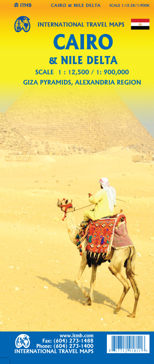
Egypt & Cairo
Ordinær pris 199,00 kr2nd Edition Following the so-called Arab spring of a few years ago, northern Africa experienced much turbulence. Egypt experienced the overthrow of the government, the installation of a radical religious-oriented replacement, and the installation of a radical religious-oriented replacement, and the installation of military governance. Tourism plummeted. Most map publishers discontinued their maps of the country. Five years later, Egypt has stabilized and tourism is growing. We feel that the time is right to re-introduce our ITMB map of Egypt.
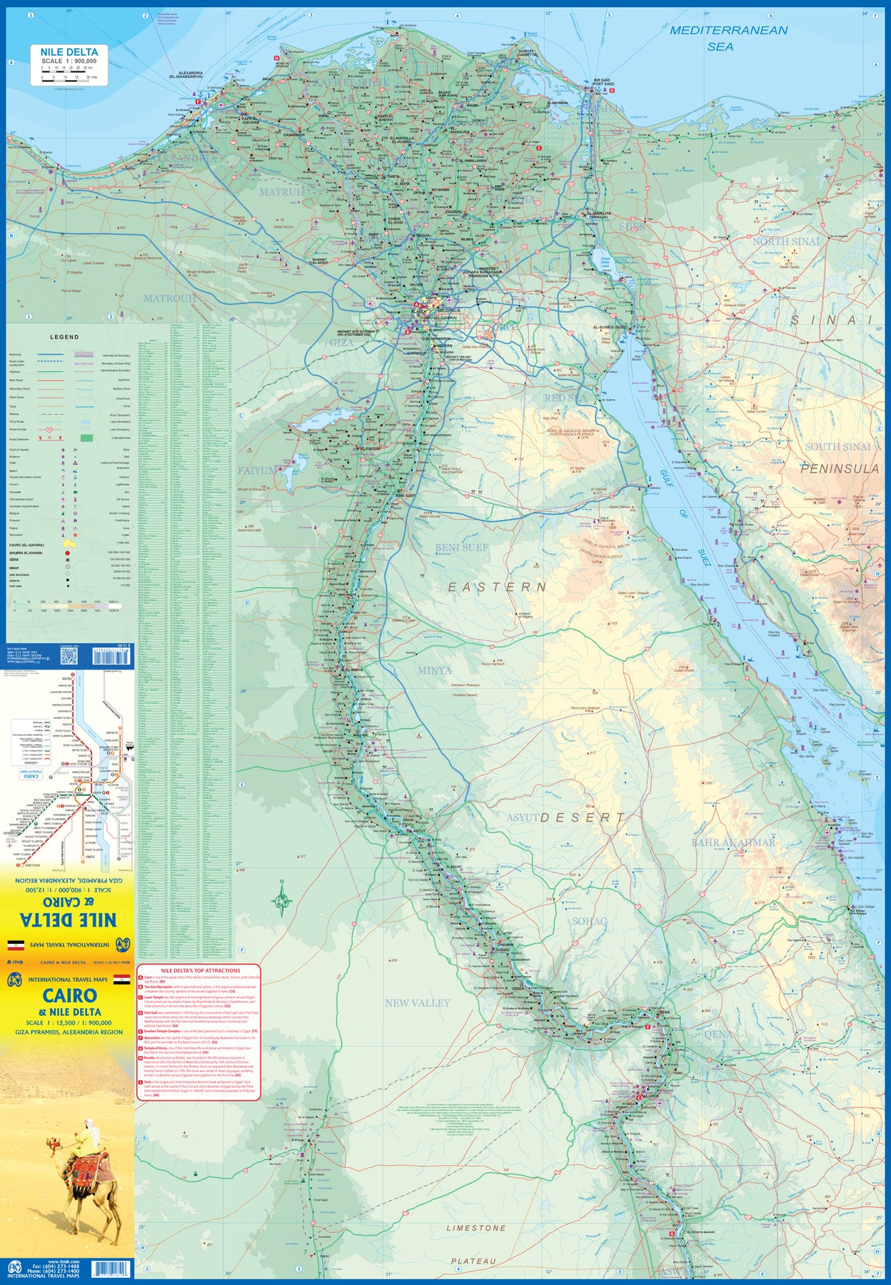
This version focuses on the portions of the country that have been re-opened for tourism, which means from the Mediterranean coastline south to the Aswan Dam. The portion further south remains closed for the moment, as is the border crossing with Sudan. We have also unrest, as the border areas with Libya remain very unstable. However, we have provided a large inset map of Egypt, covering everything, in the area of desert. We have also added a listing of Egypt's Top tombs.
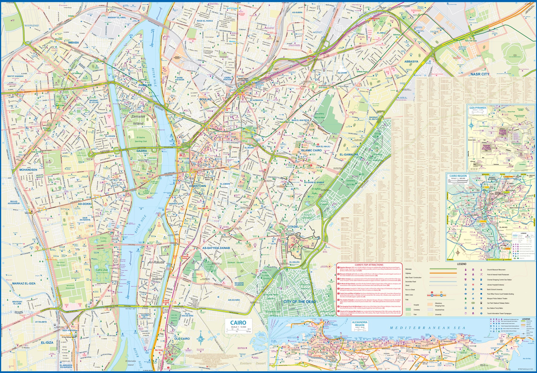
The other side of the sheet is a detailed map of Cairo, with an inset of the Giza Pyramid complex just to the west of Cairo, and another inset of the Cairo region showing all the known tombs west of the Nile River south to Helwan. The back cover is a schematic map of the rapid transit system of Cairo. There is a third inset, showing Alexandra and other associated urban areas along the coast. The maps is printed on stone paper, which is waterproof, durable, and long-lasting. It is also biodegradable.
Egypt: Cairo & Nile Delta
Ordinær pris 199,00 krCairo is one of the most vibrant and exciting cities in the world (as is Egypt as a country, which we map separately). Side 1 focuses on the city itself, with insets of Alexandria, the pyramids of Gizi, and the region immediately surrounding Cairo. The city has also expanded its rapid transit Metro system, which is shown on the back cover. An extension to the airport should open next year. The second side of the map sheet shows the delta of the Nile River, which is a gigantic flood plain, and follows the course of the river south past Cairo all the way past Luxor. Much of the Red Sea is included, as is most of the Sinai Peninsula. The famous canal is, of course, shown in detail.
This map is designed for the visitor concentrating on the most popular aspects of a trip to ancient Egypt. The map also has two Top Attraction lists, one for the city and one for the region, to make it easy for users to locate such sites as the Temple of Horus or the must-see new Museum of Egypt.
Ethiopia & Eritrea
Ordinær pris 169,00 krITM har kart over hele verden og de spesialiserer seg på land litt utenfor allfarvei. Beliggenheten til landets nasjonalparker, historiske monumenter, de viktigste veiene o.L. Finner du inkludert i kartene. Samtlige landkart har ofte et bykart over hovedstaden.
Fra ITM: Double-sided map with Ethiopia at 1:1,900,000 accompanied by a street plan of Addis Ababa, with on the reverse Eritrea at 1:915,000 with a plan of Asmara. Both road maps are indexed and show the topography by altitude colouring: in Ethiopia with bands in metres and peak heights given in both metres and feet, and in Eritrea with bands in feet and peak heights either in feet and metres or in feet only.
Ghana & Togo
Ordinær pris 189,00 krTysk kartserie med flotte kart på slitesterkt plastpapir.
Reise Know-How maps (world mapping project series) are easy-to-read, waterproof and highly durable travel maps specifically designed for everyday use on the road.
Travel know-how maps are characterized by particularly sturdy plastic paper, which can be written on like paper, even with a pencil. The cardboard envelope is removable, making it easy to put the card in any pocket. A protective cover is not required. The cartographic representation focuses on the most important information for travellers and is particularly easy to read. Instead of shading, coloured layers of elevation are used.
Publisert år: 2023
Innbinding: falset
Material: plastpapir
Målestokk: 1:600,000
HORN OF AFRICA: Ethiopia, Somalia, Eritrea & Djibouti
Ordinær pris 169,00 krTysk kartserie med flotte kart på slitesterkt plastpapir.
Ethiopia with Eritrea, Somalia and Djibouti at 1:1,800,000 on a light, waterproof and tear-resistant, indexed road map, providing both topographic and tourist information. The map, published by Reise-Know-How as part of their highly acclaimed World Mapping Project, is double-sided, with a generous overlap between the sides, to provide the best balance between a good scale and a convenient size sheet.
Road and rail networks are easy to see on a clear base which presents topography by altitude colouring with contours, spot heights, mountain passes and names of mountain ranges. Salt pans, swamps, seasonal rivers and lakes, oases, caves, hot springs and coral reefs are indicated. Road network includes seasonal local tracks, gives driving distances on main roads, and shows locations of fuel supplies and border crossings. Local airfields are also marked. Internal administrative boundaries are shown with names of the provinces. National parks and protected areas are marked and symbols highlight various places of interest, including UNESCO world heritage sites, archaeological remains, churches and monasteries, mosques, viewpoints, beaches, etc. Campsites, particularly within Ethiopia, and locations of wells and water tanks are indicated. The map has a grid with latitude and longitude at intervals of 1º, and a separate index of localities for each country, plus a list of national parks and reverse. Map legend includes English.
Publisert år: 2020
Innbinding: falset
Material: plastpapir
Målestokk: 1:1800000
Ighil Mgoun - High Atlas
Ordinær pris 189,00 krKenya
Ordinær pris 249,00 krLesotho
Ordinær pris 179,00 krInfomap™ er kongen av road-trip kart i den sørlige delen av afrika. Godt detaljerte og oppdaterte veikart i papir. Kartene inneholder også skogs - og landeveier for deg som vil utenfor allfarvei. Perfekt kompanjong på safari eller andre eventyr. Har gps-koordinater.
Publisert år: 2018
Innbinding: falset
Material: papir
Målestokk: 1:400000
Lesotho & Swaziland (Eswatini)
Ordinær pris 169,00 krITM har kart over hele verden og de spesialiserer seg på land litt utenfor allfarvei. Beliggenheten til landets nasjonalparker, historiske monumenter, de viktigste veiene o.L. Finner du inkludert i kartene. Samtlige landkart har ofte et bykart over hovedstaden.
Fra ITM: ITM is pleased to re-introduce their coverage of two countries of africa that are fairly unique. Both were well-established entities when settlers arrived, and both were able to maintain their identities throughout the colonial era, as protectorates. Lesotho is quite mountainous, with a poorly developed road network, so is a travel adventure destination. It occupies side 1, along with an inset of maseru, the capital. Swaziland, which has recently changed its name for local purposes to eswatini, occupies side 2, with an inset of mbabane, its capital. Both countries are easy to access from south africa, and are well worth visiting. We have also added two lists showing the top attractions of both countries. Both are land-locked countries either adjacent to or surrounded by south africa; both are essentially agricultural countries, although lesotho s mountainous terrain offers considerable touristic appeal, particularly the sani pass. Legend includes: Highway, main road, secondary road, street, pathway, railway, park, lake, international airport, gas station, church, hotel, museum, library, restaurant, shopping, police station, bank, school, stadium, bus terminal, golfing, etc. 2nd edition 2019. Scales: Lesotho 1:350.000, swailand 1:200.000.
Publisert år: 2019
Innbinding: falset
Material: papir
Målestokk: 1:350000
Libya
Ordinær pris 169,00 krTysk kartserie med flotte kart på slitesterkt plastpapir.
Indexed, waterproof and tear-resistant road map of Libya with topographic and tourist information, published by Reise Know-How as part of their highly acclaimed World Mapping Project. The map is double-sided to provide the best balance between a good scale and a convenient size sheet.
Road and rail networks are easy to see on a clear base which shows the area’s topography by altitude colouring with contours, spot heights, mountain passes, and names of mountain ranges. The map also shows deserts, salt lakes and seasonal rivers. Internal administrative boundaries are shown with names of the provinces. Names of main towns are also given in Arabic script. Road network includes unsurfaced roads and seasonal tracks and indicates locations of fuel supplies. A wide range of symbols highlight various places of interest, including national parks and protected areas, oasis and water wells, UNESCO world heritage sites, archaeological remains, campsites, caves, beaches, etc. Oil wells and pipelines are also marked, as well as the course of the “Great-Man-Made-River” project. The map has a latitude and longitude grid at intervals of 1° and an index of place names. Map legend includes English.
Publisert år: 2011
Innbinding: falset
Material: plastpapir
Målestokk: 1:1600000
Libya
Ordinær pris 149,00 krGizi map er en serie presise kart med detaljer og opplysninger over både populære og mindre populære reisemål. Dekker ofte områder der få andre kartprodusenter dekker.
Publisert år: 2014
Innbinding: falset
Material: papir
Målestokk: 1:1750000
Madagascar
Ordinær pris 199,00 krThe large, somewhat isolated, island of Madagascar off the east coast of Africa has unique wildlife that makes this country a naturalist's paradise. Road detail includes some tracks, and locations with petrol supplies are marked. The legend includes railways, ports, sea ferries, airports and airfields. Wetland areas, reserves and national parks are indicated, and a range of symbols depict various features e.g. historic sites, places of interest, antiquities, waterfalls, campsites, lodgings, beaches, hospitals and post offices. The islands of the Comoros and Mayotte are also included which also show main roads, airports and hotels. The map is single sided and printed on paper, topography is shown using altitude shading and some spot heights.
Incl. Minikart av byen Antananarivo.
Madagascar
Ordinær pris 189,00 krDette store østerriske kartforlaget er kjent for sin klare kartografi og gode papirkvalitet. De kommer i alle målestokker, og flere av landkartene inneholder bykart og turistinformasjon.
Malawi & Mozambique
Ordinær pris 199,00 krTravel to Africa is picking up rapidly, resulting in this updated rendition of two of the continent's most popular travel destinations. Side 1 covers Malawi, the former Nyasaland of colonial times, with its capital of Lilongwe included as an inset map. An inset of Blantyre is also provided as well as photographic text showing the main attractions of the country. Adjacent portions of Zambia, Mozambique, and Tanzania are also included. Side 2 is dedicated to Mozambique, with an inset of its capital, Maputo. Although less travelled, Mozambique offers wildlife preserves bordering on Kruger, the wonderful Gorongoza Reserve, and the coastal Bazaruto Archipelago. It also has Mocambique fortress in the far north, the historic transfer point for goods from India and Europe.
Marrakesh
Ordinær pris 99,00 krMauritania
Ordinær pris 149,00 krGizi map er en serie presise kart med detaljer og opplysninger over både populære og mindre populære reisemål. Dekker ofte områder der få andre kartprodusenter dekker.
Publisert år: 2009
Innbinding: falset
Material: papir
Målestokk: 1:1750000
Mauritania & Mali
Ordinær pris 169,00 krITM har kart over hele verden og de spesialiserer seg på land litt utenfor allfarvei. Beliggenheten til landets nasjonalparker, historiske monumenter, de viktigste veiene o.L. Finner du inkludert i kartene. Samtlige landkart har ofte et bykart over hovedstaden.
Fra ITM: In this edition, we have combined Mauritania with Mali. Although both are interesting countries, the two fit naturally together as a unit, albeit at slightly differing scales. Technically, this should be a 1st edition map, as it is the first time we have combined these two desert countries on to one sheet, but I’ll let Robert at the Library of Congress worry about the niceties of bibliographic accuracy as soon as Trump allows him to do the work he loves for a salary. Mauritania was one of the most unusual countries I visited as a young traveller. Of course, I had an advantage, in that I was too young to know that what I was doing was supposed to be impossible. I entered from what was then the Spanish Sahara via a piste (a sandy track with multiple pathways, only some of which avoid soft sand), travelling with a young Bedouin man. In Zouerate, a mining camp, I had to tie my VW campervan onto a railway flatbed car, and endure hundreds of kilometres of a sand dune wasteland before reaching Choum, and a siding where I could off-load the vehicle. The track south to Nouakchott was covered with sand and treacherous. Nowadays, there is a paved road to the southern border of Morocco, and a good road all the way along the coast to Rosso, where a ferry can take one across to Senegal. Mali adjoins Mauritania, both being formerly part of French West Africa. The capital, Bamako, is an interesting town with quite a bit of colonial architecture still in place. East of there is Djenne, a ‘forbidden’ city for infidels when I was there (see cover photo), but a fascinating mud-brick city. Further east again is Mopti, a river port where camel caravans off-load tablets of salt mined still far in the Sahara for transport by boat to Dakar. Further east again is Timbuktu (or Tombouctou as it is now spelled), at one time the most exotic isolated destination known to mankind. Further south is the Bandiagara escarpment, a must-see living area for locals who have created a living space from the sheer walls of the cliff. Both countries are fascinating places to visit.
Publisert år: 2019
Innbinding: falset
Material: Papir
Målestokk: 1:2,200,000 / 1:900,000
Morocco
Ordinær pris 169,00 krLet the Marco Polo Morocco Map guide you around this fascinating country. Discover a diverse landscape of snow-capped mountains and deserts, walled cities and wild coastlines with this highly durable touring map of Morocco. It folds away easily and is always on standby to help when you're stuck.
Morocco
Ordinær pris 189,00 krMorocco at 1:1,000,000 on an indexed road map with topographic and tourist information, printed on light, waterproof and tear-resistant plastic paper. The map, part of Reise Know-How’s highly acclaimed World Mapping Project, is double-sided to provide the best balance between a good scale and a convenient size sheet. The map divides Morocco north/south with a generous overlap between the sides: Marrakesh, the Toubkal Massif and Essaouira are included on both sides. The southern part of Western Sahara is shown as an inset at 1:2,500,000. Names of larger towns are additionally given in Arabic.
Topography is indicated by altitude colouring with spot heights and mountain passes, names of mountain ranges and peaks, seasonal rivers and lakes, salt pans, oases and wells. National parks are highlighted. Road information includes dirt roads and tracks, indicating scenic routes, locations of petrol stations and river fords, plus intermediate driving distances on main routes. Railways and local airfields are also shown. Symbols mark various places of interest: campsites, UNESCO World Heritage sites, forts and religious buildings, archaeological sites, beaches, surfing and fishing locations, viewpoints, etc. The map has a latitude/longitude grid at intervals of 1º and an index of localities. Map legend includes English.