Filter
- Algerie
- Angola
- Benin
- Botswana
- Burundi
- Djibouti
- Egypt
- Elfenbenskysten
- Eritrea
- Eswatini
- Etiopia
- Frankrike
- Gabon
- Gambia
- Ghana
- Kamerun
- Kapp Verde
- Kenya
- Komorene
- Kongo
- Lesotho
- Libya
- Madagaskar
- Malawi
- Maldivene
- Mali
- Marokko
- Mauritania
- Mauritius
- Mosambik
- Namibia
- Niger
- Nigeria
- Rwanda
- Senegal
- Seychellene
- Sierra Leone
- Somalia
- Sudan
- Sør-Afrika
- Sør-Sudan
- Tanzania
- Togo
- Tunisia
- Uganda
- Vest-Sahara
- Zambia
- Zimbabwe
112 produkter
112 produkter
Utsolgt
Africa
Freytag & Berndt
189,00 kr

Mozambique & Malawi
Ordinær pris 239,00 kr/
Mva inkludert
Frakt beregnes i kassen.
Highly tear-resistant and 100% waterproof map "Mozambique, Malawi" from the series world mapping project.
Travel know-how maps are characterized by particularly sturdy plastic paper, which can be written on like paper, even with a pencil. The cardboard envelope is removable, making it easy to put the card in any pocket. A protective cover is not required. The cartographic representation focuses on the most important information for travelers and is particularly easy to read. Instead of shading, colored layers of elevation are used.
- Contour lines with elevation information
- Colored elevation layers
- Classified road network with distance information
- Sights
- Detailed location index
- GPS-accurate
- Longitude and latitude
- Five-language legend (German, English, French, Spanish, Russian)
- With maps of Maputo and Lilongwe
- Brick South Mozambique
- Overview map on the cover
- Publisert: 2023
- Innbinding: Falset
- Materiale: Plastpapir
- Målestokk: 1:1 200 000

Namibia
Ordinær pris 199,00 kr/
Mva inkludert
Frakt beregnes i kassen.
Namibia at 1:1,000,000 from Freytag & Berndt with a separate booklet attached to the map cover also providing a street plan of central Windhoek. The map is double-sided with a very generous overlap between the sides. Caprivi Strip is shown as a separate inset at 1:1,200,000
Topography is shown by relief shading with spot heights plus graphics and/or colouring indicating sandy or rocky deserts, salt lakes or flats, wells and hot springs, etc. Many seasonal rivers and lakes are included. National parks and other protected areas are prominently highlighted.
Road network includes country tracks, with road numbers very clearly presented and distances shown on many smaller routes. Locations of petrol stations and border crossings are marked. Railway lines are included and local airports are marked. Also shown are internal administrative boundaries with names of the provinces.
Symbols highlight various places of interest including UNESCO World Heritage sites. The map has latitude and longitude lines at 1° intervals. Most place names are in larger print than found on other maps. Multilingual map legend includes English.
- Publisert: 2023-2025
- Innbinding: Falset
- Materiale: Papir
- Målestokk: 1:1 000 000

Namibia
Ordinær pris 239,00 kr/
Mva inkludert
Frakt beregnes i kassen.
Namibia at 1:1,200,000 on an indexed, waterproof and tear-resistant road map with topographic and tourist information, published by Reise Know-How as part of their highly acclaimed World Mapping Project. The map is double-sided to provide the best balance between a good scale and a convenient size sheet; the country is divided north/south with a very generous overlap and Windhoek included on both sides. The eastern Kavango and Zambezi provinces (previously the Caprivi Strip) are shown on an inset.
The country’s topography is presented by altitude colouring with contours, spot heights, mountain passes, and names of mountain ranges. The map also shows salt lakes and seasonal rivers. Internal administrative boundaries are shown with names of the provinces. Road network includes unsurfaced local roads and 4WD tracks, and shows driving distances and locations of petrol stations. Restricted access roads and areas are clearly marked. Border crossings indicate their opening times. Railway lines and local airfields are also shown.
National parks and protected zones are clearly marked. Symbols highlight numerous places of interest, including UNESCO world heritage sites, churches and archaeological sites, camping sites, hot springs, viewpoints, etc. Throughout the map numerous locations of tourist accommodation are shown graded into five categories: guest farms and hunting farms; lodges and tented lodges; rest camps and B&Bs; campsites and communal camping; and state-owned rest camps and Namibia Wildlife Resorts. The map has a latitude and longitude grid at intervals of 1° and index of localities. Map legend includes English.
- Publisert: 2023
- Innbinding: falset
- Materiale: Vannfast papir
- Målestokk: 1:1 200 000

Nigeria & Niger
Ordinær pris 149,00 kr/
Mva inkludert
Frakt beregnes i kassen.
ITM har kart over hele verden og de spesialiserer seg på land litt utenfor allfarvei. Beliggenheten til landets nasjonalparker, historiske monumenter, de viktigste veiene og lignende finner du inkludert i kartene. Samtlige landkart har ofte et bykart over hovedstaden.
4th edition November 2018. Nigeria in 1:1.600.000 and Niger in 1:2.000.000. Inset maps of Lagos Island, Lagos Region, Benin City, Abuja & Niamey.
- Publisert: 2018
- Innbinding: Falset
- Materiale: Papir
- Målestokk: 1:2 000 000, 1:1 600 000


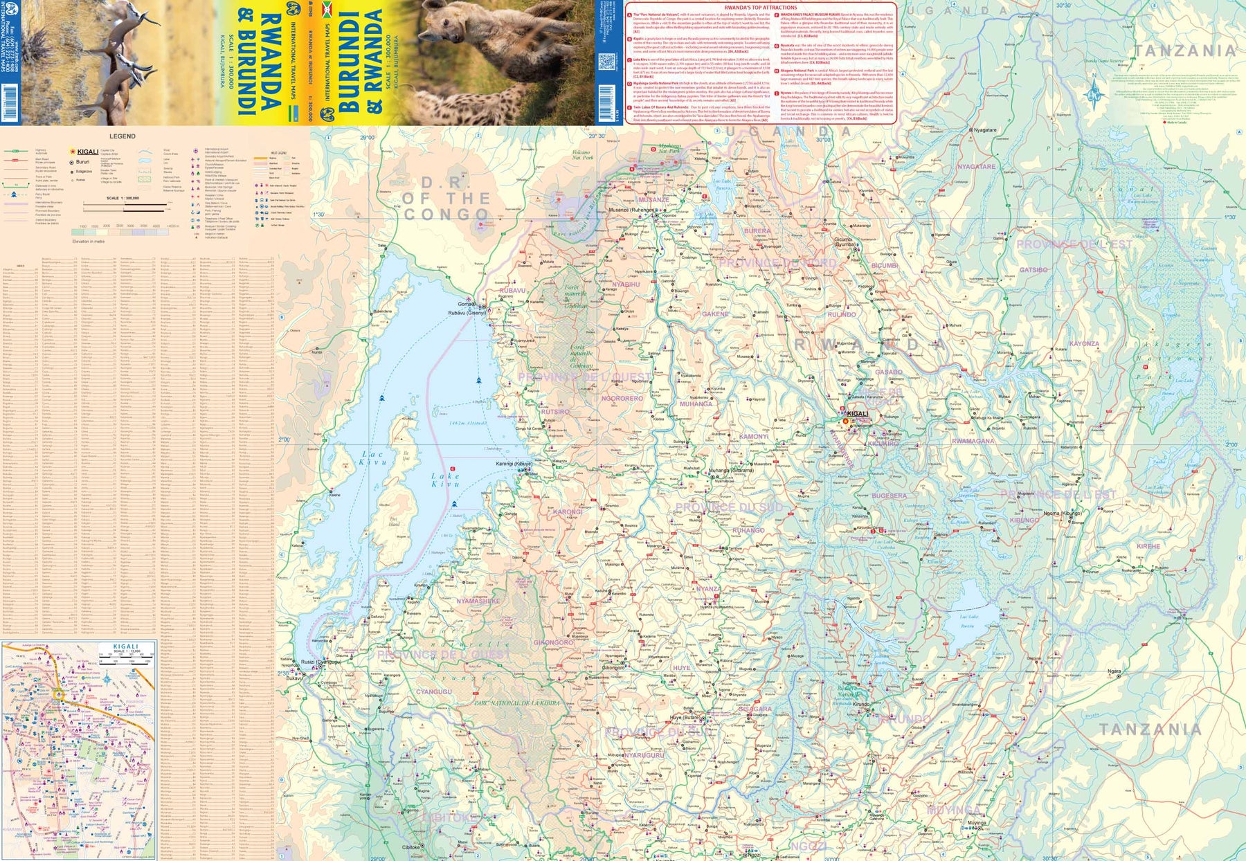
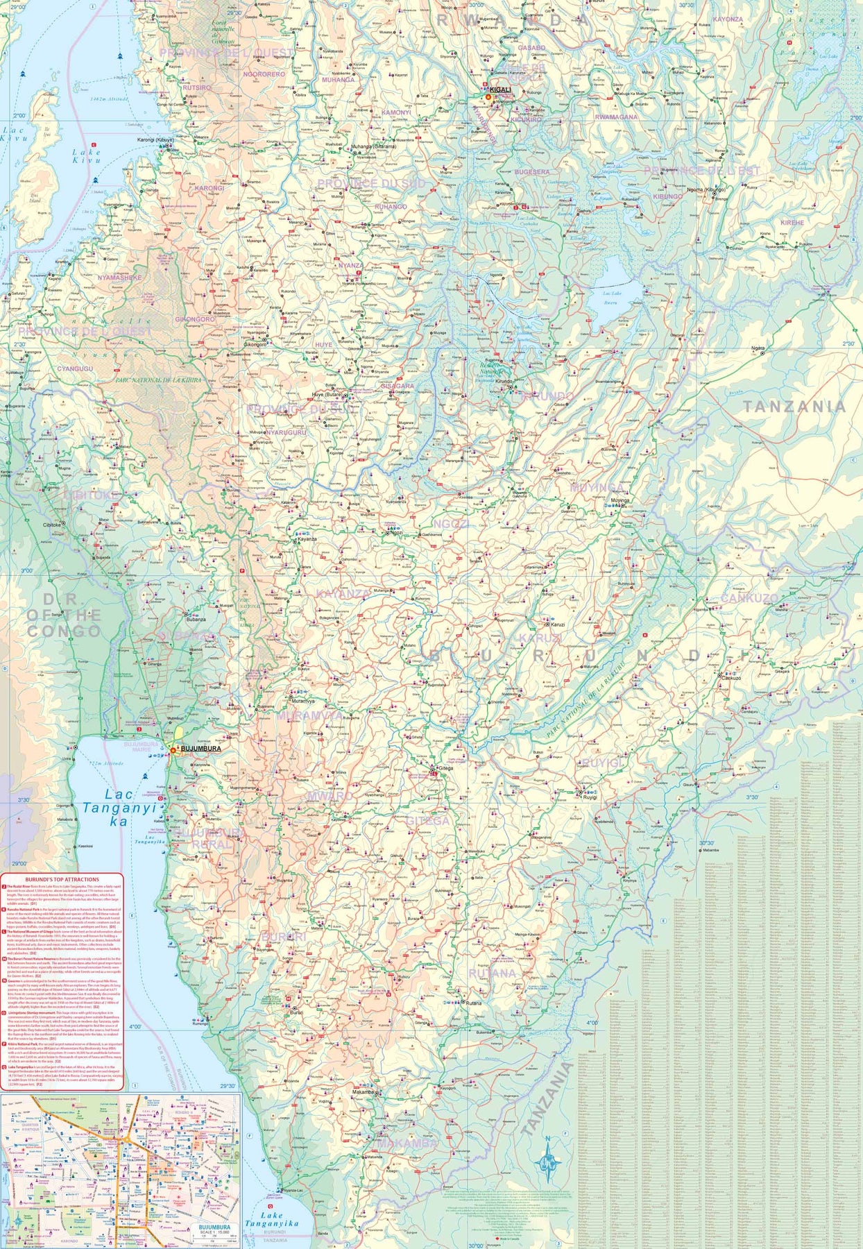
Rwanda & Burundi
Ordinær pris 179,00 kr/
Mva inkludert
Frakt beregnes i kassen.
ITM har kart over hele verden og de spesialiserer seg på land litt utenfor allfarvei. Beliggenheten til landets nasjonalparker, historiske monumenter, de viktigste veiene og lignende finner du inkludert i kartene. Samtlige landkart har ofte et bykart over hovedstaden.
Fra ITM: Both Rwanda and Burundi are former Belgian colonies lodged between DEM Congo on the west and Tanzania on the east, with a northern portion on Uganda. Being land-locked countries, the easiest way in to either country is by air or by road from Uganda or Tanzania. The region has always been referred to with Rwanda placed first, but this map has two covers, so it can be marketed equally well as Burundi & Rwanda or vice-versa. The road information is up-to-date and both countries welcome tourists. Inset maps of Kigali and Bujumbura are included.
- Publisert: 2023
- Innbinding: Falset
- Materiale: Papir
- Målestokk: 1:300 000

Senegal & The Gambia
Ordinær pris 189,00 kr/
Mva inkludert
Frakt beregnes i kassen.
Tysk kartserie med flotte kart på slitesterkt plastpapir.
Senegal and Gambia at 1:550,000 on an indexed, waterproof and tear-resistant road map of with topographic and tourist information, published by Reise Know-How as part of their highly acclaimed World Mapping Project. The map is double-sided, with a good overlap, to provide the best balance between a good scale and a convenient size sheet.
Topography is shown by altitude colouring with contours, spot heights, marshes and flooding zones, seasonal rivers, mangroves, deserts and quicksand areas, wells, oases, etc. Numerous national parks and protected areas are highlighted. Road network includes local dirt tracks, indicating driving distances on main roads. Railway lines and local airfields are also marked. Internal administrative boundaries are shown with names of the provinces. Symbols highlight various places of interest, including UNESCO heritage sites, archaeological remains, churches and mosques, selected hotels and campsites, etc. The map has a latitude and longitude grid at intervals of 30’ and an extensive index of place names. Map legend includes English.
Publisert år: 2023
Innbinding: falset
Material: plastpapir
Målestokk: 1:550000

Somalia & Horn of Africa
Ordinær pris 169,00 kr/
Mva inkludert
Frakt beregnes i kassen.
ITM har kart over hele verden og de spesialiserer seg på land litt utenfor allfarvei. Beliggenheten til landets nasjonalparker, historiske monumenter, de viktigste veiene og lignende finner du inkludert i kartene. Samtlige landkart har ofte et bykart over hovedstaden.
Fra ITM: 3rd Edition Somalia is one of the more itneresting off-the-beaten-path countries. The area around Mogadishu prefers to call itself Somalia, but controls only a portion of the overall country area. Then there is Jubaland, on the Kenyan border, aligned very closely to the former Italian colony boundaries of the same name. Truuly, an amazing juxtaposition of countries within countries! the reverse side of the sheet presents a vey interesting regional perspective of the area between the northern border of Ethiopia, a small portion of Sudan and a reasonable portion of South Sudan, all of Uganda, most of Kenya, all of Djibouti and a fair portion of Eritrea, as well as the former Aden portion of war-torn Yemen. The strategic island of Socotra is in the upper right corner. This is a fascinating regional map, never before published to my knowledge, of an extremely significant part of the world. Think of the following: Socotra guards and controls access to the Gulf of Aden and the Red Sea, leading to the Suez Canal. What an interesting part of the world! How can anyone not be captivated by such wonderfully exotic names as Hargeysa, Boosaaso, or Kismayyo? Somalia and the region of the Horn remain crucially important to world peace, so this map is important.
Publisert år: 2020
Innbinding: falset
Material: plastpapir
Målestokk: 1:1,700,000 / 1:2,400,000

Somalia & Somaliland
Ordinær pris 149,00 kr/
Mva inkludert
Frakt beregnes i kassen.
Gizi map er en serie presise kart med detaljer og opplysninger over både populære og mindre populære reisemål. Dekker ofte områder der få andre kartprodusenter dekker.
Publisert år: 2017
Innbinding: falset
Material: papir
Målestokk: 1:1750000

South Africa
Ordinær pris 199,00 kr/
Mva inkludert
Frakt beregnes i kassen.
Highly tear-resistant and 100% waterproof map "South Africa" from the series world mapping project.
Travel know-how maps are characterized by particularly sturdy plastic paper, which can be written on like paper, even with a pencil. The cardboard envelope is removable, making it easy to put the card in any pocket. A protective cover is not required. The cartographic representation focuses on the most important information for travelers and is particularly easy to read. Instead of shading, colored layers of elevation are used.
- Contour lines with elevation information
- Colored elevation layers
- Classified road network with distance information
- Sights
- Detailed location index
- GPS-accurate
- Longitude and latitude
- Five-language legend (German, English, French, Spanish, Russian)
- Publisert: 2023
- Innbinding: Falset
- Materiale: Plastpapir
- Målestokk: 1:1 400 000

South Africa - Cape Region
Ordinær pris 239,00 kr/
Mva inkludert
Frakt beregnes i kassen.
Our maps combine state-of-the-art, GPS-compatible cartography (including hypsometric tints and contour lines) with a detailed rendering of road networks and touristic information. They offer the best possible scale, level of detail and readability, be it a map of a small island or half a continent.
The maps feature a detachable paper sleeve so that the maps can be folded easily and fit in every pocket. Although printed on plastic, a special coating makes sure the maps retain a paper-like feel and can even be written on with a pencil.
- Publisert: 2024
- Innbinding: Falset
- Materiale: Plastpapir
- Målestokk: 1:500 000

South Africa: Lesotho & Swaziland (Eswatini)
Ordinær pris 199,00 kr/
Mva inkludert
Frakt beregnes i kassen.
The most southerly portion of the African continent is also one of the most scenic parts of that vast continent. South Africa was settled by Europeans in the 1500s, displacing the indigenous population. It developed into an industrial, urbanized society by WW2, but has had a troubled modern history. It is touristically attractive, with two main ports of entry – Johannesburg and Cape Town. It is easy to rent a car and drive around the country (NB: they drive on the wrong side of the road!) or enjoy a luxurious train trip between the two main cities.
The Garden Route, along the south shore, passes through vintage vineyards and enables one to explore off-the-beaten-path towns like Knysna, or explore the Transkei, or visit land-locked Lesotho. The game parks of South Africa are rightly famous. Kruger is the most famous, but my favourite is Addo, an elephant sanctuary north of Port Elizabeth. Farther north is Swaziland, which has recently changed its name to Eswatini, and further west are Botswana and Namibia, portions of which are included on the map. Finally, there is the arid Northern Cape and the Great Karoo to discover.
Includes City Centre Maps of Cape Town; Johannesburg & Pretoria
- Publisert: 2019
- Innbinding: Falset
- Materiale: Plastpapir
- Målestokk: 1:1 350 000

Sudan & South Sudan
Ordinær pris 179,00 kr/
Mva inkludert
Frakt beregnes i kassen.
ITM har kart over hele verden og de spesialiserer seg på land litt utenfor allfarvei. Beliggenheten til landets nasjonalparker, historiske monumenter, de viktigste veiene og lignende finner du inkludert i kartene. Samtlige landkart har ofte et bykart over hovedstaden.
- Publisert: 2024
- Innbinding: Falset
- Materiale: Papir
- Målestokk: 1:2 000 000


Tanzania, Rwanda & Burundi
Ordinær pris 169,00 kr/
Mva inkludert
Frakt beregnes i kassen.
Indexed, waterproof and tear-resistant road map of Tanzania showing topographic and tourist information and including a street plan of central Dar Es Salam. The map, published by Reise Know-How as part of their highly acclaimed World Mapping Project, is double-sided to provide the best balance between a good scale and a convenient size sheet. The country is divided into east and west sections with a generous overlap and coverage also includes Rwanda and Burundi.
The area’s topography is presented by altitude colouring with contours and spot height. Seasonal water features, swamps, salt lakes and mangroves are indicated. Road network includes unsurfaced local roads and seasonal tracks, and indicates driving distances on main and secondary roads and locations of petrol stations. Border crossings are clearly marked. Railways, local airfields and ferry routes, both coastal and on Lake Tanganyika, Lake Kivu and Lake Nyasa, are also shown and internal administrative boundaries are presented with names of the provinces.
National parks and nature reserves are prominently marked. Symbols highlight various places of interest, including selected hotels, campsites and lodges, viewpoints, archaeological sites, rock paintings, wells and water tanks, medical facilities, beaches and diving sites, etc. The map has a latitude and longitude grid at intervals of at 1°, plus an extensive index of localities with a separate list of national parks and reserves. Map legend includes English.
Also included is a street plan of central Dar Es Salam showing various tourist facilities and places of interest.
- Publisert: 2019
- Innbinding: Falset
- Materiale: Plastpapir
- Målestokk: 1:1 200 000

Tanzania: Kilimanjaro & Tanzania North
Ordinær pris 199,00 kr/
Mva inkludert
Frakt beregnes i kassen.
Kili remains eternally popular. This most recent update includes a listing of Top attractions for this dormant volcano. The reverse side of the map covers all of northern Tanzania and the portion of Kenya that includes Nairobi. The islands of Pemba and Zanzibar are also shown. This side also includes an inset map of Arusha, the town from which almost all treks to Kilimanjaro begin, an inset of Dar es Salaam, and another of Stone City, in Zanzibar. This map recently won an award from the International Mountaineering Association for excellence.
Inkl. bykart over Dar es Salaam; Zanzibar & Arusha
- Publisert: 2022
- Innbinding: Falset
- Materiale: Papir
- Målestokk: 1:63 000, 1:300 000

Togo & Benin
Ordinær pris 169,00 kr/
Mva inkludert
Frakt beregnes i kassen.
ITM har kart over hele verden og de spesialiserer seg på land litt utenfor allfarvei. Beliggenheten til landets nasjonalparker, historiske monumenter, de viktigste veiene og lignende finner du inkludert i kartene. Samtlige landkart har ofte et bykart over hovedstaden.
Fra ITM: The two small countries squeezed between Ghana on the west and Nigeria on the east developed out of the European colonialization of most of Africa Germany, under Kaiser Bill, was determined to create an empire to rival that of Britain, and seized a portion of the coastline close to the British-held area of Ghana and held on to it until WW1 ended Germany’s colonial aspirations. Britain and France jointly governed Togo briefly, but the territory was ceded to France until independence was granted in the 1960s. Neighbouring Benin (formerly the French colony of Dahomey) was all that the French colonial office could obtain of the rich coastal plain until the German defeat in WW1, which gained it Togo and German Cameroun, further to the east. Both countries have their points of interest, but to this day have little to do with each other. There is one border crossing on the coast, and a couple of others much farther inland, but each country operates on a north-south basis, not an east-west one. The map includes inset maps of Lome, the capital of Togo, and Porto Novo, in Benin, which is now the capital. Togo’s best sites are noted in a red inset box, with a separate box for Benin.
- Publisert: 2019
- Innbinding: Falset
- Materiale: Papir
- Målestokk: 1:530 000

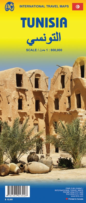
Tunisia
Ordinær pris 169,00 kr/
Mva inkludert
Frakt beregnes i kassen.
Tysk kartserie med flotte kart på slitesterkt plastpapir.
Our maps combine state-of-the-art, GPS-compatible cartography (including hypsometric tints and contour lines) with a detailed rendering of road networks and touristic information. They offer the best possible scale, level of detail and readability, be it a map of a small island or half a continent.
The maps feature a detachable paper sleeve so that the maps can be folded easily and fit in every pocket. Although printed on plastic, a special coating makes sure the maps retain a paper-like feel and can even be written on with a pencil.
Publisert år: 2018
Innbinding: falset
Material: plastpapir
Målestokk: 1:600,000


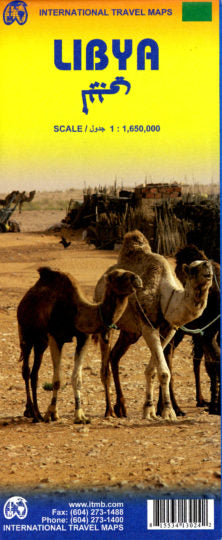
Tunisia & Libya
Ordinær pris 149,00 kr/
Mva inkludert
Frakt beregnes i kassen.
ITM har kart over hele verden og de spesialiserer seg på land litt utenfor allfarvei. Beliggenheten til landets nasjonalparker, historiske monumenter, de viktigste veiene o.L. Finner du inkludert i kartene. Samtlige landkart har ofte et bykart over hovedstaden.
Publisert år: 2011
Innbinding: falset
Material: plastpapir
Målestokk: 1:1650000


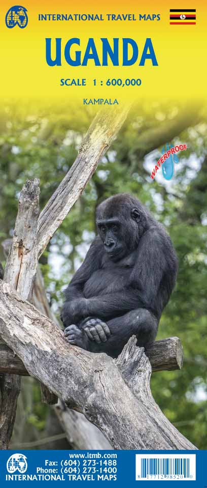

Uganda
Ordinær pris 189,00 kr/
Mva inkludert
Frakt beregnes i kassen.
ITM har kart over hele verden og de spesialiserer seg på land litt utenfor allfarvei. Beliggenheten til landets nasjonalparker, historiske monumenter, de viktigste veiene og lignende finner du inkludert i kartene. Samtlige landkart har ofte et bykart over hovedstaden.
Fra ITM: The Jewel of Africa, Uganda is a lovely country to visit. Most of the development is in the south, close to Lake Victoria. To me, the most interesting parts are the game parks in the far west and in the far north, but the Mount Elgon area is interesting as well. This updated map also includes a large inset map of Kampala, the capital. The map has been updated to last for the next few years and, by being printed on plastic, is guaranteed to remain durable as well as waterproof.
- Publisert: 2022
- Innbinding: Falset
- Materiale: Vanntett papir
- Målestokk: 1:600 000

Uganda
Ordinær pris 219,00 kr/
Mva inkludert
Frakt beregnes i kassen.
Indexed, waterproof and tear-resistant road map of Uganda with topographic and tourist information, published by Reise Know-How as part of their highly acclaimed World Mapping Project. The map is double-sided to provide the best balance between a good scale and a convenient size sheet.
The country’s topography is presented by altitude colouring with contours, spot heights, mountain passes, and names of mountain and hill ranges or plateaux. Swamps and seasonal rivers are also marked. Internal administrative boundaries are shown with names of regions and provinces. Road network includes unsurfaced local roads or tracks and shows driving distances on most roads, locations of petrol stations and border crossings. Railways, local airfields and ferry routes on Lake Victoria and Lake Albert are also shown.
National parks and protected zones are clearly marked. Symbols highlight numerous places of interest, including UNESCO world heritage and archaeological sites, hotels and lodges, camping sites, hot springs, rock paintings, viewpoints, etc. The map has a latitude and longitude grid at intervals of 30’ and index of localities. Map legend includes English.
- Publisert: 2023
- Innbinding: Falset
- Materiale: Plastpapir
- Målestokk: 1:600 000

Zimbabwe
Ordinær pris 169,00 kr/
Mva inkludert
Frakt beregnes i kassen.
Tysk kartserie med flotte kart på slitesterkt plastpapir.
Indexed, waterproof and tear-resistant road map Zimbabwe at 1:800,000 with topographic and tourist information, published by Reise Know-How as part of their highly acclaimed World Mapping Project. The map is double-sided to provide the best balance between a good scale and a convenient size sheet.
Topography is indicated by altitude colouring with numerous spot heights, names of mountain ranges and passes, salt pans, marshes and swamps. In northern Matabeleland in the Hwange National Park numerous pans are marked. Road information includes seasonal tracks and indicates intermediate driving distances on main and secondary roads. Locations of petrol stations, veterinary cordon fences and border crossings are also marked. Other transport details include railways and local airfields. Internal administrative boundaries are shown with names of the provinces.
National parks and protected areas are marked and symbols highlight various places of interest: UNESCO world heritage sites, archaeological remains, viewpoints, hot springs and wells, caves and rock paintings, selected accommodation including campsites and lodges, medical facilities, etc. The map has a latitude and longitude grid at intervals of 1° and an index of localities which includes a list of national parks and game reserves. Map legend includes English.
- Publisert: 2019
- Innbinding: Falset
- Materiale: Plastpapir
- Målestokk: 1:800 000